Laurel Fork Gorge: Difference between revisions
(→Maps: corrected Hampton trailhead coordinates) |
|||
| Line 68: | Line 68: | ||
(C) 36.27277,-82.135 | (C) 36.27277,-82.135 | ||
Laurel Fork Falls | Laurel Fork Falls | ||
(G) 36. | (G) 36.28542,-82.15211 | ||
Trailhead - Hampton | Trailhead - Hampton | ||
(G) 36.264067, -82.1231 | (G) 36.264067, -82.1231 | ||
Revision as of 12:17, 29 July 2011
| |||||||||||||||||||||||||||||||||||||

Trail Overview
The Appalachian Trail travels through Laurel Fork Gorge, rarely straying far from the creek. Probably the most popular hiking destination for TEHCC is Laurel Fork Falls, a 50' cascading waterfall. There are AT access points at both the NW end of the gorge (Hampton) and SE (Dennis Cove).
Swimming is not allowed at the falls because of dangerous undertow in the pool. Wading downstream of the falls is suggested for enjoyment.
How to get there
Hampton
- From Elizabethton, go southeast on US 321 through Hampton for 1 mile
- Look for parking area on the right 36.28542,-82.15211
Dennis Cove
- From Elizabethton, go southeast on US 321 through Hampton for .8 miles
- Turn right (south) on FR 50 (Dennis Cove Road) and travel 2(?) miles
- Look for AT access parking area on your left 36.24618,-82.12311
Route Description
Typical Conditions
Fees, Permits, etc.
Per-vehicle use fee
After the Hike
Misc. Information
Maps
<googlemap version="0.9" lat="36.27277" lon="-82.135" type="terrain" zoom="13" width="725" scale="yes" icons="http://tehcc.org/clubwiki/kml/marker{label}.png"> http://tehcc.org/clubwiki/kml/Laurel_Fork_Gorge.kml
(C) 36.27277,-82.135 Laurel Fork Falls (G) 36.28542,-82.15211 Trailhead - Hampton (G) 36.264067, -82.1231 Trailhead - Dennis Cove </googlemap>
Photos
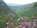
View of Laurel Fork Gorge from Potato Top
