Here's a spot to plan the 2016 (which probably will spill over to 2017) plan to hike the TEHCC maintained section of the Appalachian Trail.
Summary Table
| Month
|
Date
|
Section
|
Attending
|
| April
|
4/30
|
Spivey Gap to Nolichucky
|
Steve, Jerry, Tim M., Tim S., Connie B., Mike
|
| May
|
5/21
|
Nolichucky to Deep Gap
|
Tim S., Mike, Bill
|
| June
|
6/25
|
Deep Gap to Hughes Gap
|
Tim S.
|
| July
|
7/23
|
Hughes Gap to Overmountain Barn Shelter
|
Tim S.
|
| August
|
?
|
Overmountain Barn Shelter to 19E
|
Tim S.
|
| September
|
?
|
19E to ?
|
Tim S.
|
| October
|
?
|
?
|
Tim S.
|
| November
|
?
|
?
|
Tim S.
|
| December
|
?
|
?
|
Tim S.
|
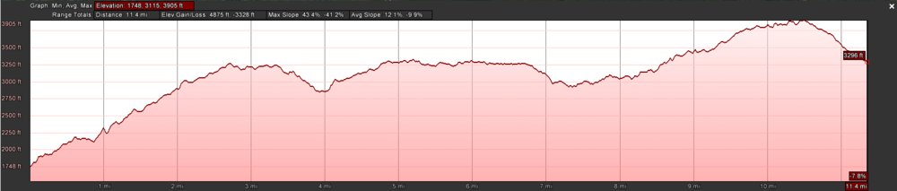
April Hike
Date: 4/30
Parking spot A: Nolichucky River Crossing - Park along road near Johnny's or across river at parking lot
Parking Spot B: Spivey Gap Crossing - Park at spaces where AT crosses 19W
Meeting Spot: McDonald's in Colonial Heights
Length: 11.4 mi
Min / Diff / Max Elevations: 1,748 / 2,157 / 3,905 ft
Ascending / Descending Change: 4,875 / -3,328 ft
Loading map...
{"type":"TERRAIN","minzoom":false,"maxzoom":false,"types":["ROADMAP","SATELLITE","HYBRID","TERRAIN"],"mappingservice":"googlemaps3","width":"auto","height":"600px","centre":{"text":"","title":"","link":"","lat":36.0689830000000029031070880591869354248046875,"lon":-82.4391289999999941073838272131979465484619140625,"icon":""},"title":"","label":"","icon":"","lines":[],"polygons":[],"circles":[],"rectangles":[],"copycoords":false,"static":false,"visitedicon":"","wmsoverlay":false,"zoom":13,"layers":[],"controls":["pan","zoom","type","scale","streetview","rotate"],"zoomstyle":"DEFAULT","typestyle":"DEFAULT","autoinfowindows":false,"resizable":false,"kmlrezoom":false,"poi":true,"cluster":false,"clustergridsize":60,"clustermaxzoom":20,"clusterzoomonclick":true,"clusteraveragecenter":true,"clusterminsize":2,"imageoverlays":[],"kml":[],"gkml":["http://tehcc.org/clubwiki/kml/AT2016Hike-Spivey_Gap_to_Nolichucky.kml"],"searchmarkers":"","fullscreen":false,"scrollwheelzoom":false,"locations":[{"text":"\u003Cdiv class=\"mw-parser-output\"\u003E\u003Cp\u003ENolichucky - Parking A\n\u003C/p\u003E\u003C/div\u003E","title":"Nolichucky - Parking A\n","link":"","lat":36.1051489999999972724253893829882144927978515625,"lon":-82.4484589999999997189661371521651744842529296875,"icon":"/clubwiki/images/MarkerA.png"},{"text":"\u003Cdiv class=\"mw-parser-output\"\u003E\u003Cp\u003ESpivey Gap - Parking B\n\u003C/p\u003E\u003C/div\u003E","title":"Spivey Gap - Parking B\n","link":"","lat":36.03192700000000314730641548521816730499267578125,"lon":-82.4202539999999999054125510156154632568359375,"icon":"/clubwiki/images/MarkerA.png"}]}
Nolichucky on Left - Spivey Gap on Right
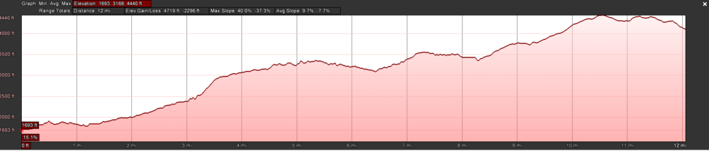
May Hike
Date: 5/21
Parking spot A: Nolichucky River - Park at trail access on Trail North side of the river
Parking Spot B: Deep Gap - Park Along Road
Meeting Spot: McDonald's in Colonial Heights
Length: 12 mi
Min / Diff / Max Elevations: 1,693 / 2,747 / 4,440 ft
Ascending / Descending Change: 4,719 / -2,296 ft
Loading map...
{"type":"TERRAIN","minzoom":false,"maxzoom":false,"types":["ROADMAP","SATELLITE","HYBRID","TERRAIN"],"mappingservice":"googlemaps3","width":"auto","height":"400px","centre":{"text":"","title":"","link":"","lat":36.11729900000000270665623247623443603515625,"lon":-82.3793210000000044601620174944400787353515625,"icon":""},"title":"","label":"","icon":"","lines":[],"polygons":[],"circles":[],"rectangles":[],"copycoords":false,"static":false,"visitedicon":"","wmsoverlay":false,"zoom":13,"layers":[],"controls":["pan","zoom","type","scale","streetview","rotate"],"zoomstyle":"DEFAULT","typestyle":"DEFAULT","autoinfowindows":false,"resizable":false,"kmlrezoom":false,"poi":true,"cluster":false,"clustergridsize":60,"clustermaxzoom":20,"clusterzoomonclick":true,"clusteraveragecenter":true,"clusterminsize":2,"imageoverlays":[],"kml":[],"gkml":["http://tehcc.org/clubwiki/kml/AT2016Hike-Nolichucky_to_Deep_Gap.kml"],"searchmarkers":"","fullscreen":false,"scrollwheelzoom":false,"locations":[{"text":"\u003Cdiv class=\"mw-parser-output\"\u003E\u003Cp\u003ENolichucky River - Parking A\n\u003C/p\u003E\u003C/div\u003E","title":"Nolichucky River - Parking A\n","link":"","lat":36.105243000000001529770088382065296173095703125,"lon":-82.4465009999999978163032210431993007659912109375,"icon":"/clubwiki/images/MarkerA.png"},{"text":"\u003Cdiv class=\"mw-parser-output\"\u003E\u003Cp\u003EDeep Gap - Parking B\n\u003C/p\u003E\u003C/div\u003E","title":"Deep Gap - Parking B\n","link":"","lat":36.12531899999999751571522210724651813507080078125,"lon":-82.312128999999998768544173799455165863037109375,"icon":"/clubwiki/images/MarkerA.png"},{"text":"\u003Cdiv class=\"mw-parser-output\"\u003E\u003Cp\u003ENorthern Departure of AT\n\u003C/p\u003E\u003C/div\u003E","title":"Northern Departure of AT\n","link":"","lat":36.14746099999999984220266924239695072174072265625,"lon":-82.1862990000000053214535000734031200408935546875,"icon":"/clubwiki/images/MarkerT.png"}]}
Nolichucky River on Left - Deep Gap on Right
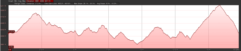
June Hike
Date: 6/25
Parking spot A: Deep Gap (Beauty Spot Gap per Google Maps/Deep Gap per AT Maps)
Parking Spot B: Hughes Gap
Meeting Spot: McDonald's in Colonial Heights
Length: 17.3 mi
Min / Diff / Max Elevations: 3,681 / 1,530 / 5,211 ft
Ascending / Descending Change: 4,933 / -4,918 ft
Loading map...
{"type":"TERRAIN","minzoom":false,"maxzoom":false,"types":["ROADMAP","SATELLITE","HYBRID","TERRAIN"],"mappingservice":"googlemaps3","width":"auto","height":"400px","centre":{"text":"","title":"","link":"","lat":36.14208099999999745932655059732496738433837890625,"lon":-82.2490360000000038098733057267963886260986328125,"icon":""},"title":"","label":"","icon":"","lines":[],"polygons":[],"circles":[],"rectangles":[],"copycoords":false,"static":false,"visitedicon":"","wmsoverlay":false,"zoom":13,"layers":[],"controls":["pan","zoom","type","scale","streetview","rotate"],"zoomstyle":"DEFAULT","typestyle":"DEFAULT","autoinfowindows":false,"resizable":false,"kmlrezoom":false,"poi":true,"cluster":false,"clustergridsize":60,"clustermaxzoom":20,"clusterzoomonclick":true,"clusteraveragecenter":true,"clusterminsize":2,"imageoverlays":[],"kml":[],"gkml":["http://tehcc.org/clubwiki/kml/AT2016Hike-Deep_Gap_to_Hughes_Gap.kml"],"searchmarkers":"","fullscreen":false,"scrollwheelzoom":false,"locations":[{"text":"\u003Cdiv class=\"mw-parser-output\"\u003E\u003Cp\u003EDeep Gap - Parking A\n\u003C/p\u003E\u003C/div\u003E","title":"Deep Gap - Parking A\n","link":"","lat":36.126035000000001673470251262187957763671875,"lon":-82.311293000000006259142537601292133331298828125,"icon":"/clubwiki/images/MarkerA.png"},{"text":"\u003Cdiv class=\"mw-parser-output\"\u003E\u003Cp\u003EHughes Gap - Parking B\n\u003C/p\u003E\u003C/div\u003E","title":"Hughes Gap - Parking B\n","link":"","lat":36.13646130000000056270437198691070079803466796875,"lon":-82.141935399999994160680216737091541290283203125,"icon":"/clubwiki/images/MarkerA.png"}]}
Hughes Gap on Left - Deep Gap on Right
July Hike
Date: 7/23
Parking spot A: Hughes Gap
Parking Spot B: Yellow Mountain Gap Trail Head or Overmountain Victory Hampton Trail Head
Meeting Spot: McDonald's in Colonial Heights
Length: 12 mi
Min / Diff / Max Elevations: 4,057 / 2,233 / 6,290 ft
Ascending / Descending Change: 3,719 / 2,941 ft
Loading map...
{"type":"TERRAIN","minzoom":false,"maxzoom":false,"types":["ROADMAP","SATELLITE","HYBRID","TERRAIN"],"mappingservice":"googlemaps3","width":"auto","height":"400px","centre":{"text":"","title":"","link":"","lat":36.1200979999999987057890393771231174468994140625,"lon":-82.087357999999994717654772102832794189453125,"icon":""},"title":"","label":"","icon":"","lines":[],"polygons":[],"circles":[],"rectangles":[],"copycoords":false,"static":false,"visitedicon":"","wmsoverlay":false,"zoom":13,"layers":[],"controls":["pan","zoom","type","scale","streetview","rotate"],"zoomstyle":"DEFAULT","typestyle":"DEFAULT","autoinfowindows":false,"resizable":false,"kmlrezoom":false,"poi":true,"cluster":false,"clustergridsize":60,"clustermaxzoom":20,"clusterzoomonclick":true,"clusteraveragecenter":true,"clusterminsize":2,"imageoverlays":[],"kml":[],"gkml":["http://tehcc.org/clubwiki/kml/AT2016Hike-Hughes_Gap_to_Barn_Shelter.kml"],"searchmarkers":"","fullscreen":false,"scrollwheelzoom":false,"locations":[{"text":"\u003Cdiv class=\"mw-parser-output\"\u003E\u003Cp\u003EHughes Gap - Parking A\n\u003C/p\u003E\u003C/div\u003E","title":"Hughes Gap - Parking A\n","link":"","lat":36.13646130000000056270437198691070079803466796875,"lon":-82.141935399999994160680216737091541290283203125,"icon":"/clubwiki/images/MarkerA.png"},{"text":"\u003Cdiv class=\"mw-parser-output\"\u003E\u003Cp\u003EYellow Mountain Gap Trail Head - Parking B\n\u003C/p\u003E\u003C/div\u003E","title":"Yellow Mountain Gap Trail Head - Parking B\n","link":"","lat":36.11696500000000042973624658770859241485595703125,"lon":-82.0488560000000006766640581190586090087890625,"icon":"/clubwiki/images/MarkerA.png"},{"text":"\u003Cdiv class=\"mw-parser-output\"\u003E\u003Cp\u003EOvermountain Victory Hampton Trail Head - Parking Alternate B\n\u003C/p\u003E\u003C/div\u003E","title":"Overmountain Victory Hampton Trail Head - Parking Alternate B\n","link":"","lat":36.1393709999999970250428305007517337799072265625,"lon":-82.05333400000000665386323817074298858642578125,"icon":"/clubwiki/images/MarkerA.png"},{"text":"\u003Cdiv class=\"mw-parser-output\"\u003E\u003Cp\u003ENorthern Departure of AT\n\u003C/p\u003E\u003C/div\u003E","title":"Northern Departure of AT\n","link":"","lat":36.12408500000000088903107098303735256195068359375,"lon":-82.056466000000000349245965480804443359375,"icon":"/clubwiki/images/MarkerT.png"}]}
August Hike
Date: 8/?
Parking spot A: Yellow Mountain Gap Trail Head or Overmountain Victory Hampton Trail Head
Parking Spot B: 19E or Buck Mountain Rd
Meeting Spot: McDonald's in Colonial Heights
Length: 10-14 mi
Min / Diff / Max Elevations: ? / ? / ? ft
Ascending / Descending Change: ? / -? ft
Loading map...
{"type":"TERRAIN","minzoom":false,"maxzoom":false,"types":["ROADMAP","SATELLITE","HYBRID","TERRAIN"],"mappingservice":"googlemaps3","width":"auto","height":"400px","centre":{"text":"","title":"","link":"","lat":36.16273199999999832243702257983386516571044921875,"lon":-82.0314599999999956025931169278919696807861328125,"icon":""},"title":"","label":"","icon":"","lines":[],"polygons":[],"circles":[],"rectangles":[],"copycoords":false,"static":false,"visitedicon":"","wmsoverlay":false,"zoom":12,"layers":[],"controls":["pan","zoom","type","scale","streetview","rotate"],"zoomstyle":"DEFAULT","typestyle":"DEFAULT","autoinfowindows":false,"resizable":false,"kmlrezoom":false,"poi":true,"cluster":false,"clustergridsize":60,"clustermaxzoom":20,"clusterzoomonclick":true,"clusteraveragecenter":true,"clusterminsize":2,"imageoverlays":[],"kml":[],"gkml":[],"searchmarkers":"","fullscreen":false,"scrollwheelzoom":false,"locations":[{"text":"\u003Cdiv class=\"mw-parser-output\"\u003E\u003Cp\u003EYellow Mountain Gap Trail Head - Parking A\n\u003C/p\u003E\u003C/div\u003E","title":"Yellow Mountain Gap Trail Head - Parking A\n","link":"","lat":36.11696500000000042973624658770859241485595703125,"lon":-82.0488560000000006766640581190586090087890625,"icon":"/clubwiki/images/MarkerA.png"},{"text":"\u003Cdiv class=\"mw-parser-output\"\u003E\u003Cp\u003EOvermountain Victory Hampton Trail Head - Parking A Alternate\n\u003C/p\u003E\u003C/div\u003E","title":"Overmountain Victory Hampton Trail Head - Parking A Alternate\n","link":"","lat":36.1393709999999970250428305007517337799072265625,"lon":-82.05333400000000665386323817074298858642578125,"icon":"/clubwiki/images/MarkerA.png"},{"text":"\u003Cdiv class=\"mw-parser-output\"\u003E\u003Cp\u003E19E Crossing - Parking B\n\u003C/p\u003E\u003C/div\u003E","title":"19E Crossing - Parking B\n","link":"","lat":36.17751299999999758938429295085370540618896484375,"lon":-82.0116909999999990077412803657352924346923828125,"icon":"/clubwiki/images/MarkerA.png"},{"text":"\u003Cdiv class=\"mw-parser-output\"\u003E\u003Cp\u003EBuck Mountain Rd Crossing - Parking B\n\u003C/p\u003E\u003C/div\u003E","title":"Buck Mountain Rd Crossing - Parking B\n","link":"","lat":36.20126900000000347290551871992647647857666015625,"lon":-81.9989680000000049631125875748693943023681640625,"icon":"/clubwiki/images/MarkerA.png"}]}


