Grayson Highlands State Park
| Grayson Highlands State Park | |
|---|---|

| |
| Park Type | State Park |
| Located | Mouth of Wilson, Virginia |
| External Links | Official Website |
| Entrance Fee | $7 per vehicle |
| ActivitiesThings to do at the park | |
| Park AmenitiesThings built to enjoy or use at the park | |
| FeaturesNatural things to see at the park | |
| Park Trails |
16 Trails / Total of 19.02 miles30.61 km <br /> |
| Lodging Types | |
| Camping Amenities |
|
| Park Area | 4,502 acres18.219 km² <br /> |
| Operated By | |
| Main Location | 36° 36' 50.15" N, 81° 28' 51.53" W Map |
|
| |
| Show In Google Maps | |
Download KML / Upload new version / KML File Page
Park Overview
Great state park has several hiking trails to panoramic vistas and scenic waterfalls with also connections to the Appalachian Trail.
Driving Directions
From Bristol, TN
- Follow I-81 north to Exit 35.
- Take Exit 35, turn right onto VA762, which becomes VA600 at blinking light.
- Follow VA762/600 12 miles to intersection with VA603.
- Continue south on VA600 after "dogleg" around businesses and reach US58 in about 8 miles.
- Turn left onto US58 east for about 10 miles to Grayson Highlands State Park (pay entry fee).
The Scales area can be directly accessed from the north side of the park.
Fees, Hours, Restrictions
Daily parking fee for Grayson Highlands is now (as of 2018) $5 for Virginia tags and $7 out-of-state.
Trails
The following trails are available in Grayson Highlands State Park.
| Park Trails | Distance | Difficulty | Marking | Usage | Highlight |
|---|---|---|---|---|---|
| AT, Wilburn Ridge, Scales | Hard |
|
|||
| Cabin Creek Trail | 1.80 mi | Medium | Yellow |
|
Loop with a waterfall and a rhododendron tunnel |
| Listening Rock Trail | 1.40 mi | Easy |
|
||
| Rhododendron Trail | Easy |
|
|||
| Twin Pinnacles Trail | 1.60 mi | Easy |
|
||
| Big Pinnacle TrailThis trail is a "stub" either because of its short length, lack of significance, or the page hasn't been created yet. The page can be created, but then delete the stub reference from this park. | 0.45 mi | Hard | Yellow | ||
| Haw Flats TrailThis trail is a "stub" either because of its short length, lack of significance, or the page hasn't been created yet. The page can be created, but then delete the stub reference from this park. | 0.62 mi | Easy | Red | ||
| Horse Trail EastThis trail is a "stub" either because of its short length, lack of significance, or the page hasn't been created yet. The page can be created, but then delete the stub reference from this park. | 2.03 mi | Medium | Orange | ||
| Horse Trail NorthThis trail is a "stub" either because of its short length, lack of significance, or the page hasn't been created yet. The page can be created, but then delete the stub reference from this park. | 0.93 mi | Medium | Orange | ||
| Rock House Ridge TrailThis trail is a "stub" either because of its short length, lack of significance, or the page hasn't been created yet. The page can be created, but then delete the stub reference from this park. | 1.25 mi | Medium | Blue | ||
| Seed Orchard RoadThis trail is a "stub" either because of its short length, lack of significance, or the page hasn't been created yet. The page can be created, but then delete the stub reference from this park. | 1.21 mi | Medium | Red | ||
| Split Rock TrailThis trail is a "stub" either because of its short length, lack of significance, or the page hasn't been created yet. The page can be created, but then delete the stub reference from this park. | 0.30 mi | Hard | Yellow | ||
| Stamper's Branch TrailThis trail is a "stub" either because of its short length, lack of significance, or the page hasn't been created yet. The page can be created, but then delete the stub reference from this park. | 1.66 mi | Medium | Yellow | ||
| Upchurch RoadThis trail is a "stub" either because of its short length, lack of significance, or the page hasn't been created yet. The page can be created, but then delete the stub reference from this park. | 3.07 mi | Medium | Orange | ||
| Wilburn Branch TrailThis trail is a "stub" either because of its short length, lack of significance, or the page hasn't been created yet. The page can be created, but then delete the stub reference from this park. | 0.94 mi | Hard | Green | ||
| Wilson Creek TrailThis trail is a "stub" either because of its short length, lack of significance, or the page hasn't been created yet. The page can be created, but then delete the stub reference from this park. | 1.76 mi | Hard | Red |
A recommended 11.6 mile loop hike would involve the AT, Wilburn Ridge, and Scales trails.
If staying at Hickory Ridge, a few options exist for loop hikes. Stamper's Branch Trail, Twin Pinnacles Trail, Big Pinnacle Trail, and returning on Horse Trail East is a good 5mi loop.
Gallery
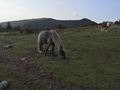
Ponies at Massie Gap