Gentry Creek Falls: Difference between revisions
(Revert vandalism) |
(Added gmap and update infobox map to standard) |
||
| Line 1: | Line 1: | ||
<!-- The following few lines create the "Infobox" table template. Please scroll down to edit the main content of the article. --> | <!-- The following few lines create the "Infobox" table template. Please scroll down to edit the main content of the article. --> | ||
{{Infobox Trail | {{Infobox Trail | ||
| Image Name = GentryCreekFalls.jpg | | Image Name = GentryCreekFalls.jpg|200px | ||
| City = Mountain City | | City = Mountain City | ||
| State = Tennessee | | State = Tennessee | ||
| Trail Use = {{Hike}}{{Dogs}}{{Waterfall}} | | Trail Use = {{Hike}}{{Dogs}}{{Waterfall}} | ||
| Difficulty Rating = Medium | | Difficulty Rating = Medium | ||
| Hike Time = 3-4 | | Hike Time = 3-4 | ||
| Line 17: | Line 15: | ||
<!-- DON'T EDIT THE GOOGLEMAP TAG --> | <!-- DON'T EDIT THE GOOGLEMAP TAG --> | ||
| googlemap = | | googlemap = | ||
<googlemap lat="36.542606" lon="-81.734673" zoom=" | <googlemap lat="36.542606" lon="-81.734673" zoom="9" width="270" type="map" height="180" selector="no" controls="small"> | ||
36.542606,-81.734673 | 36.542606,-81.734673,Gentry Creek Falls | ||
</googlemap> | </googlemap> | ||
}} | }} | ||
| Line 60: | Line 57: | ||
==Fees, Permits, etc. == | ==Fees, Permits, etc. == | ||
<!-- Please list any Fees, Permits, Regulations, etc. that may be required on this trail.--> | <!-- Please list any Fees, Permits, Regulations, etc. that may be required on this trail.--> | ||
== After the Hike == | == After the Hike == | ||
| Line 72: | Line 68: | ||
== Maps == | == Maps == | ||
<!-- You can place pictures, PDF's, links, or even create a Google map with your waypoints and place it here. --> | <!-- You can place pictures, PDF's, links, or even create a Google map with your waypoints and place it here. --> | ||
<googlemap version="0.9" lat="36.56" lon="-81.734673" type="terrain" zoom="13" width="700" scale="yes" icons="http://tehcc.org/clubwiki/kml/marker{label}.png"> | |||
http://tehcc.org/clubwiki/kml/placeholder.kml | |||
(G) 36.542606,-81.734673 | |||
Trailhead | |||
(C) 36.5677, -81.70575 | |||
Gentry Creek Falls | |||
</googlemap> | |||
== Photos == | == Photos == | ||
| Line 79: | Line 83: | ||
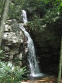
Image:GentryCreek20070811-02.jpg|Gentry Creek Waterfalls - August 2007 | Image:GentryCreek20070811-02.jpg|Gentry Creek Waterfalls - August 2007 | ||
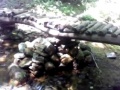
Image:GentryCreek20070811-03.jpg|Bridge crossing on Gentry Creek - Aug 2007 | Image:GentryCreek20070811-03.jpg|Bridge crossing on Gentry Creek - Aug 2007 | ||
<!-- Do not remove the end gallery code.--> | <!-- Do not remove the end gallery code.--> | ||
</gallery> | </gallery> | ||
Revision as of 21:48, 5 January 2012
| |||||||||||||||||||||||||||||||||||||

Trail Overview
Hike with 13-14 water crossings to double drop waterfall.
How to get there
From Kingsport, TN:
- Take I-81 north to Exit 19 for US-58 towards Damascus.
- Continue through Damascus.
- Take right (south) when VA-91 and US-58 split.
- Proceed back into Tennessee to Laurel Bloomery.
From Mountain City, TN:
- Proceed north on TN 91 for 7.7 miles to Laurel Bloomery.
Then for both routes:
- Turn at the A-Z Market onto Gentry Creek Road (sign to Pleasant Home Church) and proceed 0.8 miles.
- Make right turn onto Star Gap Road.
- Then quickly left again ton continue on Gentry Creek Road, which become gravel after 1.1 miles.
- Continue on rough gravel road for 1.4 miles and park at road end.
Point of information is that the first cul-de-sac parking lot reached on the gravel road is for Rogers Ridge Horse Trail. Veer to the right to continue back to the dead end cul-de-sac with a trail marker for Gentry Creek Falls.
Route Description
Hikers cross mound barriers. The trail is very gentle rise up a shaded valley with the expected numerous creek crossings over six log bridges, stepping stones, or nothing at all. Gentry Creek is pretty with small rapids. The two tiered waterfall is an enjoyable vista for lunch. Note: The upper falls can be reached by a very narrow path on the right side of the lower falls - but dangerous!
Typical Conditions
Trail is not regularly maintained, but usually passible. Difficulty of creek crossings depends on season and whether recent rains. Lots of mosquitos during summer.
Fees, Permits, etc.
After the Hike
Stop in Damascus for ice cream
Misc. Information
Gentry's Falls are named after Joseph Gentry, who farmed 800 acres in the area startng around 1796.
Maps
<googlemap version="0.9" lat="36.56" lon="-81.734673" type="terrain" zoom="13" width="700" scale="yes" icons="http://tehcc.org/clubwiki/kml/marker{label}.png"> http://tehcc.org/clubwiki/kml/placeholder.kml
(G) 36.542606,-81.734673 Trailhead (C) 36.5677, -81.70575 Gentry Creek Falls </googlemap>
Photos
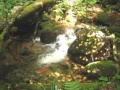
Gentry Creek August 2007
Gentry Creek Waterfalls - August 2007
Bridge crossing on Gentry Creek - Aug 2007


