GSMNP Grotto Falls: Difference between revisions
(Initial copy from Doe River Gorge Trail) |
(Populating fields - saving work in progress) |
||
| Line 1: | Line 1: | ||
<!-- The following few lines create the "Infobox" table template. Please scroll down to edit the main content of the article. --> | <!-- The following few lines create the "Infobox" table template. Please scroll down to edit the main content of the article. --> | ||
{{Infobox Trail | {{Infobox Trail | ||
| Image Name = | | Image Name = placeholder.jpg | ||
| City = Gatlinburg | | City = Gatlinburg | ||
| State = Tennessee | | State = Tennessee | ||
| Trail Use = {{Hike}} | | Trail Use = {{Hike}} | ||
| Difficulty Rating = Medium | | Difficulty Rating = Medium | ||
| Hike Time = 2 | | Hike Time = 2 | ||
| Distance = | | Distance = 3 | ||
| Elevation Gain = * | | Elevation Gain = * | ||
| High Point = * | | High Point = * | ||
| Latitude = | | Latitude = N35°40.818 | ||
| Longitude = | | Longitude = W83°27.747 | ||
| Medical = | | Medical = Sevierville | ||
<!-- DON'T EDIT THE GOOGLEMAP TAG --> | <!-- DON'T EDIT THE GOOGLEMAP TAG --> | ||
| googlemap = | | googlemap = | ||
<googlemap lat=" | <googlemap lat="35.68030" lon="-83.46245" zoom="9" width="270" type="map" height="180" selector="no" controls="small"> | ||
35.68030,-83.46245 | |||
Trailhead for Trillum Gap Trail from Roaring Fork Motor Nature Trail | |||
</googlemap> | </googlemap> | ||
}} | }} | ||
| Line 26: | Line 26: | ||
== Trail Overview == | == Trail Overview == | ||
<!-- Enter a overview of the trail. What attracts you to this trail, points of interest, types of flowers, lakes, and peaks that you see along the way. --> | <!-- Enter a overview of the trail. What attracts you to this trail, points of interest, types of flowers, lakes, and peaks that you see along the way. --> | ||
Moderate hike up through classic GSMNP forest to a waterfall you can walk behind. | |||
== How to get there == | == How to get there == | ||
<!-- Please enter detailed instruction on how to find the trail head. --> | <!-- Please enter detailed instruction on how to find the trail head. --> | ||
From | From Gatlinburg, TN: | ||
# | #At traffic light #8 on the Parkway, turn onto the Historic Nature Trail. | ||
#Proceed | #Proceed into Great Smoky Mountains National Park. | ||
#Turn right | #Turn right onto Roaring Fork Motor Nature Trail. | ||
# | #Continue to Stop #5 and park. | ||
Trailhead is | Trailhead is marked and heads uphill. | ||
== Route Description== | == Route Description== | ||
<!-- Detailed description of the route. Is there any side trails that are worth traveling? --> | <!-- Detailed description of the route. Is there any side trails that are worth traveling? --> | ||
The Trillum Gap Trail heads up the side of Mount LeConte to the Grotto waterfall and beyond. | |||
{| class="wikitable" border="1" | |||
|- | |||
!Mileage | |||
!Description | |||
|- | |||
|0.0 | |||
|Trailhead at Roaring Fork Motor Nature Trail Stop #5. | |||
|- | |||
|0.2 | |||
|Intersection of access path from parking lot with Trillum Gap Trail. | |||
|- | |||
|0.23 | |||
|First creek crossing. | |||
|- | |||
|0.65 | |||
|Second creek crossing. | |||
|- | |||
|0.9 | |||
|Third creek crossing. | |||
|- | |||
|1.1 | |||
|Fourth and last creek crossing heading up. | |||
|- | |||
|1.3 | |||
|Grotto Falls | |||
|} | |||
== Typical Conditions == | == Typical Conditions == | ||
<!-- Typical conditions throughout the year of what to expect on the trail. Rocky, muddy, sandy, flowers, lots of downed trees? --> | <!-- Typical conditions throughout the year of what to expect on the trail. Rocky, muddy, sandy, flowers, lots of downed trees? --> | ||
National Park Service does trail maintenance primarily between May thru Nov, thus some blowdowns possible during the off-season. The well-worn dirt trail also included tree roots and large stone. Can be very muddy have significant rain. | |||
== Fees, Permits, etc. == | == Fees, Permits, etc. == | ||
<!-- Please list any Fees, Permits, Regulations, etc. that may be required on this trail.--> | <!-- Please list any Fees, Permits, Regulations, etc. that may be required on this trail.--> | ||
No fee, but Roaring Fork Motor Nature Trail does not allow RVs or trailers and is only open March 11 - Nov 30 during 2011. | |||
== After the Hike == | == After the Hike == | ||
<!-- Other things to check out while you're in the area. Restaurants, attractions, monuments, etc... --> | <!-- Other things to check out while you're in the area. Restaurants, attractions, monuments, etc... --> | ||
Explore the other older cabins at the other stops along the Roaring Fork Motor Nature Trail on the way out. | |||
== Misc. Information == | == Misc. Information == | ||
<!-- Enter any additional information that doesn't fit an any other fields. Any seasonal features, factoids, etc...? --> | <!-- Enter any additional information that doesn't fit an any other fields. Any seasonal features, factoids, etc...? --> | ||
Per | Per NPS policy, pets are not allowed on park trails. | ||
== Maps == | == Maps == | ||
<!-- You can place pictures, PDF's, links, or even create a Google map with your waypoints and place it here. --> | <!-- You can place pictures, PDF's, links, or even create a Google map with your waypoints and place it here. --> | ||
<!-- Ready for the KML to be uploaded --> | |||
<googlemap version="0.9" lat="36.500667" lon="-82.47797" type="terrain" zoom="15" width="715" height="350" scale="yes" controls="large" icons="http://tehcc.org/clubwiki/kml/marker{label}.png"> | |||
http://tehcc.org/clubwiki/kml/WPSP_Devils_Backbone_Trail.kml | |||
(E) 36.50065,-82.47918 | |||
Overlook at Tee #5 | |||
(E) 36.50013,-82.47760 | |||
Lone Cedar Overlook | |||
(C) 36.49958,-82.47186 | |||
Fall Creek Falls | |||
[[Image:WPSP Fall Creek Falls.jpg|150px|Fall Creek Falls]] | |||
(A) 36.502632,-82.482759 | |||
Parking along Fall Creek Road | |||
(G) 36.502891,-82.468700 | |||
Intersection to/from [[WPSP_Fall_Creek_Loop_Trail|Fall Creek Loop]] | |||
[[Image:To D Backbone Trail.jpg|150px|Trail head sign]] | |||
(J) 36.502507,-82.482345 | |||
[[Image:Devil's_Backbone_trailhead_.jpg|150px|Trail head bridge]] | |||
(J) 36.50051,-82.47105 | |||
Trail bridge | |||
</googlemap> | |||
[[File:WPSP Devil's Backbone Trail profile.JPG]] | |||
Revision as of 21:34, 31 March 2011
| |||||||||||||||||||||||||||||||||||||
Trail Overview
Moderate hike up through classic GSMNP forest to a waterfall you can walk behind.
How to get there
From Gatlinburg, TN:
- At traffic light #8 on the Parkway, turn onto the Historic Nature Trail.
- Proceed into Great Smoky Mountains National Park.
- Turn right onto Roaring Fork Motor Nature Trail.
- Continue to Stop #5 and park.
Trailhead is marked and heads uphill.
Route Description
The Trillum Gap Trail heads up the side of Mount LeConte to the Grotto waterfall and beyond.
| Mileage | Description |
|---|---|
| 0.0 | Trailhead at Roaring Fork Motor Nature Trail Stop #5. |
| 0.2 | Intersection of access path from parking lot with Trillum Gap Trail. |
| 0.23 | First creek crossing. |
| 0.65 | Second creek crossing. |
| 0.9 | Third creek crossing. |
| 1.1 | Fourth and last creek crossing heading up. |
| 1.3 | Grotto Falls |
Typical Conditions
National Park Service does trail maintenance primarily between May thru Nov, thus some blowdowns possible during the off-season. The well-worn dirt trail also included tree roots and large stone. Can be very muddy have significant rain.
Fees, Permits, etc.
No fee, but Roaring Fork Motor Nature Trail does not allow RVs or trailers and is only open March 11 - Nov 30 during 2011.
After the Hike
Explore the other older cabins at the other stops along the Roaring Fork Motor Nature Trail on the way out.
Misc. Information
Per NPS policy, pets are not allowed on park trails.
Maps
<googlemap version="0.9" lat="36.500667" lon="-82.47797" type="terrain" zoom="15" width="715" height="350" scale="yes" controls="large" icons="http://tehcc.org/clubwiki/kml/marker{label}.png">
http://tehcc.org/clubwiki/kml/WPSP_Devils_Backbone_Trail.kml
(E) 36.50065,-82.47918
Overlook at Tee #5
(E) 36.50013,-82.47760
Lone Cedar Overlook
(C) 36.49958,-82.47186
Fall Creek Falls
 (A) 36.502632,-82.482759
Parking along Fall Creek Road
(G) 36.502891,-82.468700
Intersection to/from Fall Creek Loop
(A) 36.502632,-82.482759
Parking along Fall Creek Road
(G) 36.502891,-82.468700
Intersection to/from Fall Creek Loop
 (J) 36.502507,-82.482345
 (J) 36.50051,-82.47105
Trail bridge
</googlemap>
(J) 36.50051,-82.47105
Trail bridge
</googlemap>

Photos
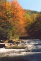
Trail follows Doe River
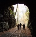
Walking thru one of two tunnels

