GSMNP Grotto Falls: Difference between revisions
m (No trail marking) |
(→Trail Overview: Adding link to main GSMNP trail page) |
||
| Line 21: | Line 21: | ||
== Trail Overview == | == Trail Overview == | ||
<!-- Enter a overview of the trail. What attracts you to this trail, points of interest, types of flowers, lakes, and peaks that you see along the way. --> | <!-- Enter a overview of the trail. What attracts you to this trail, points of interest, types of flowers, lakes, and peaks that you see along the way. --> | ||
Located in the [[Great Smoky Mountains National Park]], a moderate hike up through classic forest to a waterfall you can walk behind. | |||
== How to get there == | == How to get there == | ||
Revision as of 07:21, 10 October 2014
| |||||||||||||||||||||||||||||||||||||
Trail Overview
Located in the Great Smoky Mountains National Park, a moderate hike up through classic forest to a waterfall you can walk behind.
How to get there
From Gatlinburg, TN:
- At traffic light #8 on the Parkway, turn onto the Historic Nature Trail.
- Proceed into Great Smoky Mountains National Park.
- Turn right onto Roaring Fork Motor Nature Trail.
- Continue to Stop #5 and park.
Trailhead is marked and heads uphill.
Route Description
The Trillum Gap Trail heads up the side of Mount LeConte to the Grotto waterfall and beyond.
| Mileage | Description |
|---|---|
| 0.0 | Trailhead at Roaring Fork Motor Nature Trail Stop #5. |
| 0.2 | Intersection of access path from parking lot with Trillum Gap Trail. |
| 0.23 | First creek crossing. |
| 0.65 | Second creek crossing. |
| 0.9 | Third creek crossing. |
| 1.1 | Fourth and last creek crossing heading up. |
| 1.4 | Grotto Falls |
Typical Conditions
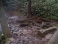
National Park Service does trail maintenance primarily between May thru Nov, thus some blowdowns possible during the off-season. The well-worn dirt trail also included tree roots and large stone. Can be very muddy have significant rain.
Fees, Permits, etc.
No fee, but Roaring Fork Motor Nature Trail does not allow RVs or trailers and is only open March 11 - Nov 30 during 2011. During peak summer season, you might spend more time on this roadway than on the trail.
If the Roaring Fork Motor Trail closed, then next nearest access point would be at the Rainbow Falls trailhead for a 7 mile round trip hike.
After the Hike
Explore the other older cabins at the other stops along the Roaring Fork Motor Nature Trail on the way out.
Misc. Information
Per NPS policy, pets are not allowed on park trails.
Maps
<googlemap version="0.9" lat="35.6775" lon="-83.455" type="terrain" zoom="15" width="650" height="350" scale="yes" controls="large" icons="http://tehcc.org/clubwiki/kml/marker{label}.png">
http://tehcc.org/clubwiki/kml/GSMNP_Grotto_Falls.kml
(A) 35.68030,-83.46245
Trailhead at Roaring Fork Motor Nature Trail
 (G) 35.67940,-83.46091
Intersection of parking access and Trillum Gap Trail
(G) 35.67940,-83.46091
Intersection of parking access and Trillum Gap Trail
 (J) 35.67896,-83.46065
First creek crossing
(J) 35.67896,-83.46065
First creek crossing
 (J) 35.67692,-83.45635
Second creek crossing
(J) 35.67664,-83.45376
Last creek crossing
(C) 35.67367,-83.4496
Grotto Falls
(J) 35.67692,-83.45635
Second creek crossing
(J) 35.67664,-83.45376
Last creek crossing
(C) 35.67367,-83.4496
Grotto Falls
 </googlemap>

Photos
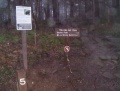
Trillum Gap Trailhead
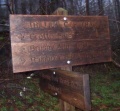
Trail intersection sign
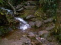
First Creek Crossing
Fourth Creek Crossing
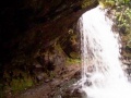
path behind Grotto Falls
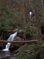
Almost there - cascade downstream
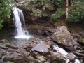
Grotto Falls
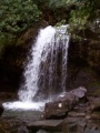
Grotto Falls


