Ewing Trail
| |||||||||||||||||||||||||||||||||||||

Trail Overview
Loop hike up side of Cumberland Mountain to see enormous wind-carved Sand Cave and then over to White Rock cliffs for expansive view south into Tennessee.
How to get there
From Gate City, VA
- Continue on US 23/58/421 to Duffield, VA .
- Turn left on US 58/421 in Duffield and continue 11 miles to Stickleyville, VA.
- Continue on US 58 west where US 421 turns north.
- Proceed on US 58 about 25 miles to Ewing, VA although the highway is on a new bypass north of town.
- Turn right at traffic lights onto VA724.
- Proceed about a mile to the Thomas Walker Civic Park.
- Park in grass by pit toilets for day hike. (Park back outside gate if returning after dark.)
- Trailhead is behind the covered pavilion (which has only a handicapped parking space).
Route Description
Hikers walk up through picnic area to trail leading uphill from the far end into the woods. The road past the Civic Park is the horse trail and the two trails join in a few hundred yards. From Picnic area and shelter, proceed north into woods and trail which later merges with horse trail and ascends mountain with switchbacks. At summit take left fork toward Southwest and proceed to junction with Sand Cave Trail to right descending into Kentucky. Proceed to Sand Cave. Backtrack up from Sand Cave and take trail to left to climb to White Rocks overlook. A bypass trail leads down to the main trail up from Ewing for a short cut return.
Typical Conditions
Being a national park, the trails are fairly well maintained. Varies from narrow hard packed hiking only trail to wide roadway/horse trail. The path is very rocky at times with loose gravel. Another challenge is diverting water off the trail path, thus many water bars. After a rain, several water crossings will be encountered with might have well placed stepping stones in place. Access to White Rock overlook a steep climb up a crevice.
Fees, Permits, etc.
No permits or fees required for day hiking. Permit needed from main park visitors center if camping in the backcountry. Dogs need to be on a leash.
After the Hike
Duffield is closest town on way back with several fast food options.
Misc. Information
Maps
<googlemap version="0.9" lat="36.659" lon="-83.44" type="terrain" zoom="14" width="700" scale="yes" icons="http://tehcc.org/clubwiki/kml/marker{label}.png"> http://tehcc.org/clubwiki/kml/CGNP_Sand_Cave_and_White_Rocks.kml
(G) 36.652730,-83.436074 Trailhead (G) trail intersection (E) White Rocks (G) Trail intersection (G) Trails intersection (A) Parking Area (Q) bathroom </googlemap>
Photos
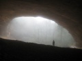
View from within the Sand Cave
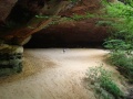
View into Sand Cave
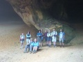
Group photo from Sept 2008 Hike

