Ewing Trail: Difference between revisions
(→Maps: Renaming kml to fix association) |
(Editing based on weekend hike) |
||
| Line 2: | Line 2: | ||
{{Infobox Trail | {{Infobox Trail | ||
| Image Name = SandCave.JPG | | Image Name = SandCave.JPG | ||
| Hike Time = 4.5 | |||
| Hike Time = | |||
| City = Ewing | | City = Ewing | ||
| State = Virginia | | State = Virginia | ||
| Trail Use = {{Hike}}{{Dogs}}{{Camping}} | | Trail Use = {{Hike}}{{Dogs}}{{Camping}} | ||
| Difficulty Rating = Moderate | | Difficulty Rating = Moderate | ||
| Distance = | | Distance = 7.5 | ||
| Elevation Gain = 1,500 | | Elevation Gain = 1,500 | ||
| High Point = * | | High Point = * | ||
| Latitude = 36.651207 | | Latitude = 36.651207 | ||
| Longitude = -83.435493 | | Longitude = -83.435493 | ||
| Medical = | | Medical = Middlesboro, KY | ||
<!-- DON'T EDIT THE GOOGLEMAP TAG --> | <!-- DON'T EDIT THE GOOGLEMAP TAG --> | ||
| googlemap = | | googlemap = | ||
| Line 20: | Line 18: | ||
36.651207,-83.435493,Sand Cave and White Rocks | 36.651207,-83.435493,Sand Cave and White Rocks | ||
</googlemap> | </googlemap> | ||
}} | }} | ||
<!-- End Infobox template table--> | <!-- End Infobox template table--> | ||
| Line 28: | Line 24: | ||
== Trail Overview == | == Trail Overview == | ||
<!-- Enter a overview of the trail. What attracts you to this trail, points of interest, types of flowers, lakes, and peaks that you see along the way. --> | <!-- Enter a overview of the trail. What attracts you to this trail, points of interest, types of flowers, lakes, and peaks that you see along the way. --> | ||
Cumberland Mountain | Loop hike up side of Cumberland Mountain to see enormous wind-carved Sand Cave and then over to White Rock cliffs for expansive view south into Tennessee. | ||
== How to get there == | == How to get there == | ||
| Line 37: | Line 33: | ||
#Continue on US 58 west where US 421 turns north. | #Continue on US 58 west where US 421 turns north. | ||
#Proceed on US 58 about 25 miles to Ewing, VA although the highway is on a new bypass north of town. | #Proceed on US 58 about 25 miles to Ewing, VA although the highway is on a new bypass north of town. | ||
#Turn right | #Turn right at traffic lights onto VA724. | ||
#Park | #Proceed about a mile to the Thomas Walker Civic Park. | ||
#Park in grass by pit toilets for day hike. (Park back outside gate if returning after dark.) | |||
#Trailhead is behind the covered pavilion (which has only a handicapped parking space). | |||
== Route Description== | == Route Description== | ||
| Line 46: | Line 44: | ||
== Typical Conditions == | == Typical Conditions == | ||
<!-- Typical conditions throughout the year of what to expect on the trail. Rocky, muddy, sandy, flowers, lots of downed trees? --> | <!-- Typical conditions throughout the year of what to expect on the trail. Rocky, muddy, sandy, flowers, lots of downed trees? --> | ||
Being a national park, the trails are fairly well maintained. Varies from narrow hard packed hiking only trail to wide roadway/horse trail. The path is very rocky at times with loose gravel. Another challenge is diverting water off the trail path, thus many water bars. After a rain, several water crossings will be encountered with might have well placed stepping stones in place. Access to White Rock overlook a steep climb up a crevice. | |||
==Fees, Permits, etc. == | ==Fees, Permits, etc. == | ||
<!-- Please list any Fees, Permits, Regulations, etc. that may be required on this trail.--> | <!-- Please list any Fees, Permits, Regulations, etc. that may be required on this trail.--> | ||
No permits or fees required for day hiking. Permit needed from main park visitors center if camping in the backcountry. Dogs need to be on a leash. | |||
== After the Hike == | == After the Hike == | ||
<!-- Where to get a good meal after a long days hike. Because I know everyone will be hungry!! --> | <!-- Where to get a good meal after a long days hike. Because I know everyone will be hungry!! --> | ||
Duffield is closest town on way back with several fast food options. | |||
== Misc. Information == | == Misc. Information == | ||
<!-- Enter any additional information that doesn't fit an any other fields. | <!-- Enter any additional information that doesn't fit an any other fields. --> | ||
== Maps == | == Maps == | ||
| Line 63: | Line 62: | ||
http://tehcc.org/clubwiki/kml/CGNP_Sand_Cave_and_White_Rocks.kml | http://tehcc.org/clubwiki/kml/CGNP_Sand_Cave_and_White_Rocks.kml | ||
(G) Trailhead | (G) 36.652730,-83.436074 | ||
Trailhead | |||
(G) trail intersection | (G) trail intersection | ||
(E) | (E) | ||
| Line 86: | Line 86: | ||
<!-- Finally add the trail to any Categories it should belong to. Please keep the State category. To make a new category just type [[Category:mycategory]]. Keep in mind categories are case sensitive. --> | <!-- Finally add the trail to any Categories it should belong to. Please keep the State category. To make a new category just type [[Category:mycategory]]. Keep in mind categories are case sensitive. --> | ||
[[Category:Virginia]] [[Category:Dog Friendly]] [[Category:Medium]] | [[Category:Virginia]] [[Category:Dog Friendly]] [[Category:Medium]] [[Category:Overlook]] | ||
Revision as of 06:02, 24 August 2011
| |||||||||||||||||||||||||||||||||||||

Trail Overview
Loop hike up side of Cumberland Mountain to see enormous wind-carved Sand Cave and then over to White Rock cliffs for expansive view south into Tennessee.
How to get there
From Gate City, VA
- Continue on US 23/58/421 to Duffield, VA .
- Turn left on US 58/421 in Duffield and continue 11 miles to Stickleyville, VA.
- Continue on US 58 west where US 421 turns north.
- Proceed on US 58 about 25 miles to Ewing, VA although the highway is on a new bypass north of town.
- Turn right at traffic lights onto VA724.
- Proceed about a mile to the Thomas Walker Civic Park.
- Park in grass by pit toilets for day hike. (Park back outside gate if returning after dark.)
- Trailhead is behind the covered pavilion (which has only a handicapped parking space).
Route Description
Hikers walk up through picnic area to trail leading uphill from the far end into the woods. The road past the Civic Park is the horse trail and the two trails join in a few hundred yards. From Picnic area and shelter, proceed north into woods and trail which later merges with horse trail and ascends mountain with switchbacks. At summit take left fork toward Southwest and proceed to junction with Sand Cave Trail to right descending into Kentucky. Proceed to Sand Cave. Backtrack up from Sand Cave and take trail to left to climb to White Rocks overlook. A bypass trail leads down to the main trail up from Ewing for a short cut return.
Typical Conditions
Being a national park, the trails are fairly well maintained. Varies from narrow hard packed hiking only trail to wide roadway/horse trail. The path is very rocky at times with loose gravel. Another challenge is diverting water off the trail path, thus many water bars. After a rain, several water crossings will be encountered with might have well placed stepping stones in place. Access to White Rock overlook a steep climb up a crevice.
Fees, Permits, etc.
No permits or fees required for day hiking. Permit needed from main park visitors center if camping in the backcountry. Dogs need to be on a leash.
After the Hike
Duffield is closest town on way back with several fast food options.
Misc. Information
Maps
<googlemap version="0.9" lat="36.659" lon="-83.44" type="terrain" zoom="14" width="700" scale="yes" icons="http://tehcc.org/clubwiki/kml/marker{label}.png"> http://tehcc.org/clubwiki/kml/CGNP_Sand_Cave_and_White_Rocks.kml
(G) 36.652730,-83.436074 Trailhead (G) trail intersection (E) White Rocks (G) Trail intersection (G) Trails intersection (A) Parking Area (Q) bathroom </googlemap>
Photos
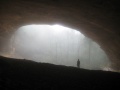
View from within the Sand Cave
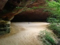
View into Sand Cave
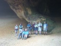
Group photo from Sept 2008 Hike

