Ewing Trail: Difference between revisions
m (added old fire tower) |
m (added captions and panoramic view) |
||
| Line 66: | Line 66: | ||
<gallery> | <gallery> | ||
<!-- Place any pictures from this trail below. Add a picture by typing Image:imagename.extension --> | <!-- Place any pictures from this trail below. Add a picture by typing Image:imagename.extension --> | ||
Image:SandCave.JPG | Image:SandCave.JPG|View of the Sand Cave | ||
Image:White_Rock_-_old_fire_tower.jpg | Image:White_Rock_-_old_fire_tower.jpg|Old fire tower on top of White Rock | ||
Image:White_Rock_-_panoramic_view.jpg|Panoramic view from White Rock | |||
<!-- Do not remove the end gallery code.--> | <!-- Do not remove the end gallery code.--> | ||
Revision as of 10:35, 24 May 2011
| |||||||||||||||||||||||||||||||||||||

Trail Overview
Cumberland Mountain, enormous Sand Cave, 3 acre rock shelter, and White Rocks Cliffs over Ewing, VA
How to get there
From Gate City, VA
- Continue on US 23/58/421 to Duffield, VA .
- Turn left on US 58/421 in Duffield and continue 11 miles to Stickleyville, VA.
- Continue on US 58 west where US 421 turns north.
- Proceed on US 58 about 25 miles to Ewing, VA although the highway is on a new bypass north of town.
- Turn right on VA 724 in Ewing area and proceed about a mile to the parking lot of the Civic Park on swinging down to left.
- Park here at the Trailhead.
Route Description
Hikers walk up through picnic area to trail leading uphill from the far end into the woods. The road past the Civic Park is the horse trail and the two trails join in a few hundred yards. From Picnic area and shelter, proceed north into woods and trail which later merges with horse trail and ascends mountain with switchbacks. At summit take left fork toward Southwest and proceed to junction with Sand Cave Trail to right descending into Kentucky. Proceed to Sand Cave. Backtrack up from Sand Cave and take trail to left to climb to White Rocks overlook. A bypass trail leads down to the main trail up from Ewing for a short cut return.
Typical Conditions
The trails are fairly well maintained.
Fees, Permits, etc.
After the Hike
Misc. Information
Maps
Photos

View of the Sand Cave
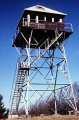
Old fire tower on top of White Rock

Panoramic view from White Rock
