Doe River Gorge: Difference between revisions
Jump to navigation
Jump to search
(Adding photos from club image library and moved coords to DRG office) |
|||
| Line 1: | Line 1: | ||
<!-- The following few lines create the "Infobox" table template. Please scroll down to edit the main content of the article. --> | <!-- The following few lines create the "Infobox" table template. Please scroll down to edit the main content of the article. --> | ||
{{Infobox Trail | {{Infobox Trail | ||
| Image Name = | | Image Name = Doe-River-2.jpg | ||
| City = Hampton | | City = Hampton | ||
| State = Tennessee | | State = Tennessee | ||
| Trail Use = {{Hike}} | | Trail Use = {{Hike}} | ||
| Difficulty Rating = Easy | | Difficulty Rating = Easy | ||
| Hike Time = | | Hike Time = 2-3 | ||
| Distance = 4-5 | | Distance = 4-5 | ||
| Elevation Gain = * | | Elevation Gain = * | ||
| High Point = * | | High Point = * | ||
| Latitude = | | Latitude = N36°16.026 | ||
| Longitude = | | Longitude = W82°10.410 | ||
| Medical = Elizabethton, TN | | Medical = Elizabethton, TN | ||
<!-- DON'T EDIT THE GOOGLEMAP TAG --> | <!-- DON'T EDIT THE GOOGLEMAP TAG --> | ||
| googlemap = | | googlemap = | ||
<googlemap lat=" | <googlemap lat="36.2671" lon="-82.1735" zoom="11" width="270" type="map" height="180" selector="no" controls="small"> | ||
36.2671,-82.1735 | |||
Doe River Ministry Offices | |||
</googlemap> | </googlemap> | ||
}} | }} | ||
| Line 64: | Line 65: | ||
<!-- Place any pictures from this trail below. Ideally we would have a picture of the trailhead to help people know when they found it --> | <!-- Place any pictures from this trail below. Ideally we would have a picture of the trailhead to help people know when they found it --> | ||
<!-- Add a picture by typing Image:imagename.extension --> | <!-- Add a picture by typing Image:imagename.extension --> | ||
Image: | Image:Doe-River 1.jpg|Trail follows Doe River | ||
Image:Doe River Gorge Tunnel -2008.jpg|Walking thru one of two tunnels | |||
<!-- Do not remove the end gallery code.--> | <!-- Do not remove the end gallery code.--> | ||
</gallery> | </gallery> | ||
<!-- Finally add the trail to any Categories it should belong to. Please keep the State category. To make a new category just type [[Category:mycategory]]. Keep in mind categories are case sensitive. Check here ClubWIKI:Categorization_Plan for our list of categories that we are using --> | <!-- Finally add the trail to any Categories it should belong to. Please keep the State category. To make a new category just type [[Category:mycategory]]. Keep in mind categories are case sensitive. Check here ClubWIKI:Categorization_Plan for our list of categories that we are using --> | ||
Revision as of 10:07, 24 March 2011
| |||||||||||||||||||||||||||||||||||||

Trail Overview
Easy 4-5 mile hike following an old railroad through two tunnels. Views of towering cliffs, stream, and forest.
How to get there
From Kingsport, TN:
- Head south on I-26 to Exit 24 (Elizabethton).
- Proceed on US321 for eight miles into town.
- Turn right at traffic light to stay on US321 heading south.
- After six miles, enter driveway for Doe River Ministries.
Trailhead is behind the sleeping cabooses.
Route Description
Typical Conditions
Fees, Permits, etc.
Permission to hike the trail must be obtained prior to the trip from Doe River Gorge Ministries Tel: (423) 725-4010
After the Hike
Misc. Information
Maps
Photos
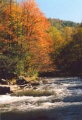
Trail follows Doe River
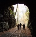
Walking thru one of two tunnels

