Doe River Gorge: Difference between revisions
m (→Fees, Permits, etc.: may have figure out needed to use "media") |
(Updating fields after hike) |
||
| Line 6: | Line 6: | ||
| Trail Use = {{Hike}} | | Trail Use = {{Hike}} | ||
| Difficulty Rating = Easy | | Difficulty Rating = Easy | ||
| Hike Time = | | Hike Time = 3 | ||
| Distance = | | Distance = 5 | ||
| Elevation Gain = * | | Elevation Gain = * | ||
| High Point = * | | High Point = * | ||
| Line 25: | Line 25: | ||
== Trail Overview == | == Trail Overview == | ||
Easy 5 mile round trip hike following an old railroad through two tunnels. Views of towering cliffs, stream, and forest. | |||
Easy | |||
== How to get there == | == How to get there == | ||
From Kingsport, TN: | From Kingsport, TN: | ||
#Head south on I-26 to Exit 24 (Elizabethton). | #Head south on I-26 to Exit 24 (Elizabethton). | ||
#Proceed on US321 for eight miles into town. | #Proceed on US321 for eight miles into town. | ||
#Turn right at traffic light to stay on US321 heading south. | #Turn right at traffic light to stay on US321 heading south. | ||
#After six miles, enter driveway for Doe River Ministries. | #After six miles, enter driveway for Doe River Ministries. (Note: very small direction sign in highway median.) | ||
Trailhead is behind the sleeping cabooses. | #Park by the red caboose. | ||
Trailhead is behind and between the sleeping cabooses and swimming area. | |||
== Route Description== | == Route Description== | ||
The route is very simple - follow the railroad bed up to the former truss bridge and back. | |||
{| class="wikitable" border="1" | |||
|- | |||
!Distance | |||
!Doe River Gorge Trail | |||
|- | |||
|0.0 mi | |||
|Trailhead by rail switch. | |||
|- | |||
|0.1 | |||
|First tunnel. | |||
|- | |||
|0.9 | |||
|Dirt spur trail heads left and downhill to lower zipline platform by river. Do not take per visitors' agreement. | |||
|- | |||
|1.0 | |||
|Second tunnel. | |||
|- | |||
|2.0 | |||
|Orange sign for end of trail travel. | |||
|- | |||
|2.5 | |||
|End of hiking trail at former truss bridge - DO NOT ATTEMPT TO CROSS! | |||
|} | |||
== Typical Conditions == | == Typical Conditions == | ||
Wide and settled gravel railroad bed with small changes in grade, thus easy path. The one side is a steep drop down to Doe River, thus small childrn will need to be watched. | Wide and settled gravel railroad bed with small changes in grade, thus easy path. The one side is a steep drop down to Doe River, thus small childrn will need to be watched. | ||
== Fees, Permits, etc. == | == Fees, Permits, etc. == | ||
Permission to hike the trail must be obtained prior to the trip from [http://www.doerivergorge.com/index.html Doe River Gorge Ministries] Tel: (423) 725-4010 | Permission to hike the trail must be obtained prior to the trip from [http://www.doerivergorge.com/index.html Doe River Gorge Ministries] Tel: (423) 725-4010 | ||
<br>Each person (or family) will need to fill out and sign a [[Media:Doe_River_Gorge_Visitor_Registration_Form.pdf|visitor release form]], which is then dropped off in the train mail box at the front of the offices. | <br>Each person (or family) will need to fill out and sign a [[Media:Doe_River_Gorge_Visitor_Registration_Form.pdf|visitor release form]], which is then dropped off in the train mail box at the front of the offices. | ||
== After the Hike == | == After the Hike == | ||
Elizabethton has several places to enjoy for dinner. | |||
== Misc. Information == | == Misc. Information == | ||
| Line 65: | Line 84: | ||
== Maps == | == Maps == | ||
<!-- You can place pictures, PDF's, links, or even create a Google map with your waypoints and place it here. --> | <!-- You can place pictures, PDF's, links, or even create a Google map with your waypoints and place it here. --> | ||
<googlemap version="0.9" lat="36.49028" lon="-82.478" type="terrain" zoom="15" width="400" height="350" scale="yes" controls="large" icons="http://tehcc.org/clubwiki/kml/marker{label}.png"> | |||
http://tehcc.org/clubwiki/kml/Doe_River_Gorge.kml | |||
(A) 36.49028,-82.47718 | |||
Parking | |||
(G) 36.486698,-82.480163 | |||
Trailhead | |||
(R) 36.48795,-82.47944 | |||
Tunnel #1 | |||
(R) 36.48719,-82.47995 | |||
Tunnel #2 | |||
(G) 36.49072,-82.48223 | |||
End of trail at truss | |||
</googlemap> | |||
| Line 70: | Line 103: | ||
<gallery> | <gallery> | ||
<!-- Place any pictures from this trail below. Ideally we would have a picture of the trailhead to help people know when they found it --> | <!-- Place any pictures from this trail below. Ideally we would have a picture of the trailhead to help people know when they found it --> | ||
Image:Doe-River 1.jpg|Trail follows Doe River | Image:Doe-River 1.jpg|Trail follows Doe River | ||
Image:Doe River Gorge Tunnel -2008.jpg|Walking thru one of two tunnels | Image:Doe River Gorge Tunnel -2008.jpg|Walking thru one of two tunnels | ||
| Line 76: | Line 108: | ||
</gallery> | </gallery> | ||
<!-- Finally add the trail to any Categories it should belong to. Please keep the State category. To make a new category just type | Wildflower Gallery - Peak time to visit might be middle of May. | ||
[[Category:Tennessee]] [[Category:Easy]] | <gallery> | ||
Image:Doe_River_Gorge1.jpg|Flower name 1 | |||
Image:Doe_River_Gorge2.jpg|Flower name 2 | |||
</gallery> | |||
<!-- Finally add the trail to any Categories it should belong to. Please keep the State category. To make a new category just type [[Category:Tennessee]] [[Category:Easy]] | |||
Revision as of 21:39, 10 April 2011
| |||||||||||||||||||||||||||||||||||||

Trail Overview
Easy 5 mile round trip hike following an old railroad through two tunnels. Views of towering cliffs, stream, and forest.
How to get there
From Kingsport, TN:
- Head south on I-26 to Exit 24 (Elizabethton).
- Proceed on US321 for eight miles into town.
- Turn right at traffic light to stay on US321 heading south.
- After six miles, enter driveway for Doe River Ministries. (Note: very small direction sign in highway median.)
- Park by the red caboose.
Trailhead is behind and between the sleeping cabooses and swimming area.
Route Description
The route is very simple - follow the railroad bed up to the former truss bridge and back.
| Distance | Doe River Gorge Trail |
|---|---|
| 0.0 mi | Trailhead by rail switch. |
| 0.1 | First tunnel. |
| 0.9 | Dirt spur trail heads left and downhill to lower zipline platform by river. Do not take per visitors' agreement. |
| 1.0 | Second tunnel. |
| 2.0 | Orange sign for end of trail travel. |
| 2.5 | End of hiking trail at former truss bridge - DO NOT ATTEMPT TO CROSS! |
Typical Conditions
Wide and settled gravel railroad bed with small changes in grade, thus easy path. The one side is a steep drop down to Doe River, thus small childrn will need to be watched.
Fees, Permits, etc.
Permission to hike the trail must be obtained prior to the trip from Doe River Gorge Ministries Tel: (423) 725-4010
Each person (or family) will need to fill out and sign a visitor release form, which is then dropped off in the train mail box at the front of the offices.
After the Hike
Elizabethton has several places to enjoy for dinner.
Misc. Information
Per their visitation policy:
NO SMOKING
NO PETS
NO MINORS ALONE
HIKING ON RAILROAD BED ONLY
NO THROWING ROCKS AT ANY TIME - which may be a challenge given the river runs right along the gravel railroad bed
Maps
<googlemap version="0.9" lat="36.49028" lon="-82.478" type="terrain" zoom="15" width="400" height="350" scale="yes" controls="large" icons="http://tehcc.org/clubwiki/kml/marker{label}.png"> http://tehcc.org/clubwiki/kml/Doe_River_Gorge.kml (A) 36.49028,-82.47718 Parking (G) 36.486698,-82.480163 Trailhead (R) 36.48795,-82.47944 Tunnel #1 (R) 36.48719,-82.47995 Tunnel #2 (G) 36.49072,-82.48223 End of trail at truss </googlemap>
Photos
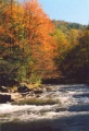
Trail follows Doe River
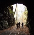
Walking thru one of two tunnels


Wildflower Gallery - Peak time to visit might be middle of May.
- Doe River Gorge1.jpg
Flower name 1
- Doe River Gorge2.jpg
Flower name 2