Blue blazed park trail. Almost all of the 300 ft elevation gain happens in the first half mile of the trail as you head straight up the ridge. There are two overlooks as you go. One at #5 tee box on the golf course, a good turn around point for families and those not interested in the rest of the climb. The Rocky Point Overlook (the trail high point on the ridge) is another 0.35 miles past the #5 tee. After the ascent the trail drops back to lake level and is steeper than the initial ascent, something to remember for a return trip.
While the park keeps the trails fairly clear of blowdowns, the trend is rutted and washed out on steep inclines. The path through lowlands by the creek can get muddy after a rain or flood in the spring deluges.
None needed, just park and go.
The path for Devil's Backbone Trail is shown in red below, while Fall Creek Loop is shown in dark blue for reference.
Loading map...
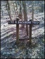
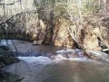
{"type":"TERRAIN","minzoom":false,"maxzoom":false,"types":["ROADMAP","SATELLITE","HYBRID","TERRAIN"],"mappingservice":"googlemaps3","width":"auto","height":"450px","centre":false,"title":"","label":"","icon":"","lines":[],"polygons":[],"circles":[],"rectangles":[],"copycoords":false,"static":false,"visitedicon":"","wmsoverlay":false,"zoom":false,"layers":[],"controls":["pan","zoom","type","scale","streetview","rotate"],"zoomstyle":"DEFAULT","typestyle":"DEFAULT","autoinfowindows":false,"resizable":false,"kmlrezoom":false,"poi":true,"cluster":false,"clustergridsize":60,"clustermaxzoom":20,"clusterzoomonclick":true,"clusteraveragecenter":true,"clusterminsize":2,"imageoverlays":[],"kml":[],"gkml":["http://tehcc.org/clubwiki/kml/WPSP_Devils_Backbone_Trail.kml","http://tehcc.org/clubwiki/kml/WPSP_Fall_Creek_Loop_Trail.kml"],"searchmarkers":"","fullscreen":false,"scrollwheelzoom":false,"locations":[{"text":"\u003Cdiv class=\"mw-parser-output\"\u003E\u003Cp\u003EOverlook at Tee #5\n\u003C/p\u003E\u003C/div\u003E","title":"Overlook at Tee #5\n","link":"","lat":36.50065000000000026147972675971686840057373046875,"lon":-82.4791799999999994952304405160248279571533203125,"icon":"/clubwiki/images/MarkerE.png"},{"text":"\u003Cdiv class=\"mw-parser-output\"\u003E\u003Cp\u003ELone Cedar Overlook\n\u003C/p\u003E\u003C/div\u003E","title":"Lone Cedar Overlook\n","link":"","lat":36.5001299999999986312104738317430019378662109375,"lon":-82.47759999999999536157702095806598663330078125,"icon":"/clubwiki/images/MarkerE.png"},{"text":"\u003Cb\u003E\u003Cdiv class=\"mw-parser-output\"\u003E\u003Cp\u003EFall Creek Falls\n\u003C/p\u003E\u003C/div\u003E\u003C/b\u003E\u003Cdiv class=\"mw-parser-output\"\u003E\u003Cp\u003E\u003Ca href=\"/wiki/File:WPSP_Fall_Creek_Falls.jpg\" class=\"image\" title=\"Fall Creek Falls\"\u003E\u003Cimg alt=\"Fall Creek Falls\" src=\"/clubwiki/images/thumb/WPSP_Fall_Creek_Falls.jpg/150px-WPSP_Fall_Creek_Falls.jpg\" decoding=\"async\" width=\"150\" height=\"114\" srcset=\"/clubwiki/images/thumb/WPSP_Fall_Creek_Falls.jpg/225px-WPSP_Fall_Creek_Falls.jpg 1.5x, /clubwiki/images/WPSP_Fall_Creek_Falls.jpg 2x\" data-file-width=\"251\" data-file-height=\"191\" /\u003E\u003C/a\u003E\n\u003C/p\u003E\u003C/div\u003E","title":"Fall Creek Falls\n","link":"","lat":36.49958000000000168938640854321420192718505859375,"lon":-82.4718600000000066074790083803236484527587890625,"icon":"/clubwiki/images/MarkerC.png"},{"text":"\u003Cdiv class=\"mw-parser-output\"\u003E\u003Cp\u003EParking along Fall Creek Road\n\u003C/p\u003E\u003C/div\u003E","title":"Parking along Fall Creek Road\n","link":"","lat":36.50263199999999841338649275712668895721435546875,"lon":-82.4827590000000014924808056093752384185791015625,"icon":"/clubwiki/images/MarkerA.png"},{"text":"\u003Cb\u003E\u003Cdiv class=\"mw-parser-output\"\u003E\u003Cp\u003EIntersection to/from \u003Ca href=\"/wiki/WPSP_Fall_Creek_Loop_Trail\" class=\"mw-redirect\" title=\"WPSP Fall Creek Loop Trail\"\u003EFall Creek Loop\u003C/a\u003E\n\u003C/p\u003E\u003C/div\u003E\u003C/b\u003E\u003Cdiv class=\"mw-parser-output\"\u003E\u003Cp\u003E\u003Ca href=\"/wiki/File:To_D_Backbone_Trail.jpg\" class=\"image\" title=\"Trail head sign\"\u003E\u003Cimg alt=\"Trail head sign\" src=\"/clubwiki/images/thumb/To_D_Backbone_Trail.jpg/150px-To_D_Backbone_Trail.jpg\" decoding=\"async\" width=\"150\" height=\"199\" srcset=\"/clubwiki/images/thumb/To_D_Backbone_Trail.jpg/225px-To_D_Backbone_Trail.jpg 1.5x, /clubwiki/images/To_D_Backbone_Trail.jpg 2x\" data-file-width=\"265\" data-file-height=\"351\" /\u003E\u003C/a\u003E\n\u003C/p\u003E\u003C/div\u003E","title":"Intersection to/from Fall Creek Loop\n","link":"","lat":36.50289099999999820056473254226148128509521484375,"lon":-82.4686999999999983401721692644059658050537109375,"icon":"/clubwiki/images/MarkerG.png"},{"text":"\u003Cb\u003E\u003Cdiv class=\"mw-parser-output\"\u003E\u003Cp\u003ETrailhead sign\n\u003C/p\u003E\u003C/div\u003E\u003C/b\u003E\u003Cdiv class=\"mw-parser-output\"\u003E\u003Cp\u003E\u003Ca href=\"/wiki/File:Devil%27s_Backbone_trailhead_.jpg\" class=\"image\" title=\"Trail head bridge\"\u003E\u003Cimg alt=\"Trail head bridge\" src=\"/clubwiki/images/thumb/Devil%27s_Backbone_trailhead_.jpg/150px-Devil%27s_Backbone_trailhead_.jpg\" decoding=\"async\" width=\"150\" height=\"113\" srcset=\"/clubwiki/images/thumb/Devil%27s_Backbone_trailhead_.jpg/225px-Devil%27s_Backbone_trailhead_.jpg 1.5x, /clubwiki/images/thumb/Devil%27s_Backbone_trailhead_.jpg/300px-Devil%27s_Backbone_trailhead_.jpg 2x\" data-file-width=\"768\" data-file-height=\"576\" /\u003E\u003C/a\u003E\n\u003C/p\u003E\u003C/div\u003E","title":"Trailhead sign\n","link":"","lat":36.50250700000000136924427351914346218109130859375,"lon":-82.4823449999999951387508190236985683441162109375,"icon":"/clubwiki/images/MarkerL.png"},{"text":"\u003Cdiv class=\"mw-parser-output\"\u003E\u003Cp\u003ETrail bridge\n\u003C/p\u003E\u003C/div\u003E","title":"Trail bridge\n","link":"","lat":36.50050999999999845613274374045431613922119140625,"lon":-82.4710500000000052978066378273069858551025390625,"icon":"/clubwiki/images/MarkerL.png"},{"text":"\u003Cdiv class=\"mw-parser-output\"\u003E\u003Cp\u003EDouble blaze for spur trail\n\u003C/p\u003E\u003C/div\u003E","title":"Double blaze for spur trail\n","link":"","lat":36.5002300000000019508661353029310703277587890625,"lon":-82.4714799999999996771293808706104755401611328125,"icon":"/clubwiki/images/MarkerG.png"}]}