Devil's Backbone: Difference between revisions
(Update IB to new format) |
(→Maps: Updating for new Maps extension) |
||
| Line 99: | Line 99: | ||
<!-- Ready for the KML to be uploaded --> | <!-- Ready for the KML to be uploaded --> | ||
< | <display_map type="terrain" width="auto" height="450" gkml="http://tehcc.org/clubwiki/kml/WPSP_Devils_Backbone_Trail.kml, | ||
http://tehcc.org/clubwiki/kml/WPSP_Devils_Backbone_Trail.kml | http://tehcc.org/clubwiki/kml/WPSP_Fall_Creek_Loop_Trail.kml"> | ||
http://tehcc.org/clubwiki/kml/WPSP_Fall_Creek_Loop_Trail.kml | 36.50065,-82.47918~Overlook at Tee #5~ ~MarkerE.png | ||
36.50013,-82.47760~Lone Cedar Overlook~ ~MarkerE.png | |||
Overlook at Tee #5 | 36.49958,-82.47186~Fall Creek Falls~[[Image:WPSP Fall Creek Falls.jpg|150px|Fall Creek Falls]]~MarkerC.png | ||
36.502632,-82.482759~Parking along Fall Creek Road~ ~MarkerA.png | |||
Lone Cedar Overlook | 36.502891,-82.468700~Intersection to/from [[WPSP_Fall_Creek_Loop_Trail|Fall Creek Loop]]~[[Image:To D Backbone Trail.jpg|150px|Trail head sign]]~MarkerG.png | ||
36.502507,-82.482345~Trailhead sign~[[Image:Devil's_Backbone_trailhead_.jpg|150px|Trail head bridge]]~MarkerL.png | |||
Fall Creek Falls | 36.50051,-82.47105~Trail bridge~ ~MarkerL.png | ||
[[Image:WPSP Fall Creek Falls.jpg|150px|Fall Creek Falls]] | 36.50023,-82.47148~Double blaze for spur trail~ ~MarkerG.png | ||
</display_map> | |||
Parking along Fall Creek Road | |||
Intersection to/from [[WPSP_Fall_Creek_Loop_Trail|Fall Creek Loop]] | |||
[[Image:To D Backbone Trail.jpg|150px|Trail head sign]] | |||
[[Image:Devil's_Backbone_trailhead_.jpg|150px|Trail head bridge]] | |||
Trail bridge | |||
Double blaze for spur trail | |||
</ | |||
[[File:WPSP Devil's Backbone Trail profile.JPG]] | [[File:WPSP Devil's Backbone Trail profile.JPG]] | ||
Revision as of 07:44, 22 August 2015
| |||||||||||||||||||||||||||||||||||||

Trail Overview
Located in Warriors Path State Park. Nice hike nearby for those in Kingsport. Good views of the Fort Patrick Henry Lake from the top of the ridge.
How to get there
From Kingsport, TN
- Take Fort Henry Drive to left at traffic light onto Hemlock Rd.
- Make the hard left right in front of Warriors Path Park entrance to follow the road onto Fall Creek Rd.
- Cross the bridge over Patrick Henry Lake.
- Park at the first pull-off on the right at the golf cart crossing. (Space for 4-6 vehicles - leave gap for golf carts)
- Trail begins on the back corner of #17 tee crossing the small bridge with trail sign.
Route Description
Blue blazed park trail. Almost all of the 300 ft elevation gain happens in the first half mile of the trail as you head straight up the ridge. There are two overlooks as you go. One at #5 tee box on the golf course, a good turn around point for families and those not interested in the rest of the climb. The Rocky Point Overlook (the trail high point on the ridge) is another 0.35 miles past the #5 tee. After the ascent the trail drops back to lake level and is steeper than the initial ascent, something to remember for a return trip.
| Mileage | Devil's Backbone Trail |
|---|---|
| -0.04 | Parking along Fall Creek Road |
| 0.00 | Trailhead, at sign and bridge |
| 0.05 | Veer left up the hill (not straight which is a fishing spur trail) |
| 0.35 | Overlook at Tee #5 |
| 0.50 | Lone Cedar Overlook |
| 0.6 | Turn along shore of lake inlet |
| 0.75 | Leave lake area and begin following Fall Creek upstream. |
| 0.8 | Fall Creek Falls (rapids) |
| 0.85 | Dark blue double blaze shows trail spur leading up the hill. This alternate route is not being maintained as the northern bridge over Fall Creek was washed out several years ago - thus dead end. Passes a few former abandoned home sites. |
| 0.9 | Trail bridge over Fall Creek |
| 1.0 | Stone rubble from former home chimney along trail |
| 1.2 | Intersection with Fall Creek Loop Trail |
The Devil's Backbone Trail intersects with the Fall Creek Loop Trail for a nice 1.0 mile walk around old pasture lands past several old home sites through gentler hills.
Typical Conditions
While the park keeps the trails fairly clear of blowdowns, the trend is rutted and washed out on steep inclines. The path through lowlands by the creek can get muddy after a rain or flood in the spring deluges.
Fees, Permits, etc.
None needed, just park and go.
After the Hike
Misc. Information
Maps
The path for WPSP Devil's Backbone Trail is shown in red below, while Fall Creek Loop is shown in dark blue for reference.

Photos
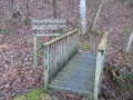
Footbridge at Fall Creek Road trailhead
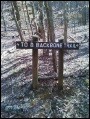
Trailhead sign at intersection with Fall Creek Loop
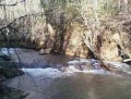
Fall Creek Falls (cascades)

