Coon Den Falls: Difference between revisions
(→Maps: Roadwalk segment) |
(→Maps: Corrections based on actual GPSr track) |
||
| Line 112: | Line 112: | ||
<display_map type="terrain" height="600" width="auto" gkml="http://tehcc.org/clubwiki/kml/CNF_Coon_Den_Falls_Trail.kml, http://tehcc.org/clubwiki/kml/CNF_Coon_Den_Falls_roadwalk_segment.kml"> | <display_map type="terrain" height="600" width="auto" gkml="http://tehcc.org/clubwiki/kml/CNF_Coon_Den_Falls_Trail.kml, http://tehcc.org/clubwiki/kml/CNF_Coon_Den_Falls_roadwalk_segment.kml"> | ||
36.26407, -82.1231~ | 36.26407, -82.1231~Dennis Cove A.T. parking area~ ~MarkerA.png | ||
36.2591, -82.11503~Very limited parking at trailhead~ ~MarkerA.png | 36.2591, -82.11503~Very limited parking at lower trailhead~ ~MarkerA.png | ||
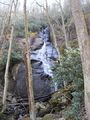
36.25333, -82.11888~Coon Den Falls~ ~MarkerC.png | 36.25333, -82.11888~Coon Den Falls~ ~MarkerC.png | ||
36. | 36.25433, -82.124083~Upper trailhead off Appalachian Trail~ ~MarkerG.png | ||
36.27277, -82.135~Laurel Fork Falls~[[Image:Laurel Fork Gorge Falls.JPG|150px]]~MarkerC.png | 36.27277, -82.135~Laurel Fork Falls~[[Image:Laurel Fork Gorge Falls.JPG|150px]]~MarkerC.png | ||
</display_map> | </display_map> | ||
Revision as of 10:05, 28 May 2016
| |||||||||||||||||||||||||||||||||||||||||||

Trail Overview
Short, steep hike to a small, but tall cascading waterfall in the Dennis Cove area
How to get there
From Johnson City, TN
- Head south on Roan Street for 3.5 miles passing under I-26.
- Take left/east onto TN359/Okolona Road and travel 1.4 miles.
- Take right/south onto TN361 over to US19E for nine miles. The road starts as Laurels Road, then Dry Creek Road and finally Gap Creek Road.
- Follow US321 including left turn into town of Hampton.
- Take right onto Dennis Cove Road.
- At 4.2 miles, the Appalachian Trail crosses the road with parking on left. An option if making a full loop hike.
- At 4.5 miles to Coon Den Falls trailhead is on right, with just space for a single vehicle. Trail is marked as CNF 37 with blue blazes.
Route Description
The falls are 0.5 mile up the moderately steep trail. An in-and-out hike can be 1.0-1.6 miles round trip depending on where you had to park.
A 3.3 mile loop hike can be created by joining the A.T., blue blaze, and road walk. Park at the A.T. lot. Head southbound on the A.T. uphill following the white blazes through older farm pasture, and into the forest. A couple of rock outcroppings provide views of the nearby mountains. At 1.7 miles, take left onto blue blazed Coon Den Falls Trail located in a saddle. Travel downhill for 0.8 miles to reach the falls on right. For this loop, once done admiring the falls, continue another 0.5 miles down to the roadway. Hang a left and carefully walk 0.6 mile single file facing traffic back to parking.
| Miles | Coon Den Falls Loop Hike | Elevation |
|---|---|---|
| 0.0 miles | Parking Area | 2,515 feet |
| 1.7 miles | Upper Trailhead on A.T. | 3,140 feet |
| 2.5 miles | Waterfall | 4,843 feet |
| 3.0 miles | Lower trailhead | 2,580 feet |
| 3.6 miles | Dennis Cove parking area | 2,515 feet |
Typical Conditions
A steep and rocky trail follows Coon Den Branch stream. If you connect with the A.T., a short section is very steep. In April 2016, the upper trail section was fairly overgrown.
Fees, Permits, etc.
No permit or fee.
After the Hike
Double waterfall day... head over to Laurel Falls for another experience.
Misc. Information
This path used to be part of the Appalachian Trail, until the latter was relocated.
Hike referenced in ATC TN-NC Guidebook under Side/Loop Hikes.
Maps
Photos
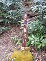
Trailhead Marker
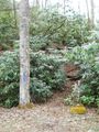
Lower Trailhead
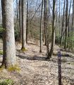
Upper Trailhead on A.T.


