Chimney Top: Difference between revisions
(Changed coords for trailhead so that Google Maps routes to right spot) |
(→Misc. Information: Add reference to GSMNP Chimney Tops since some confusion) |
||
| Line 70: | Line 70: | ||
<!-- Enter any additional information that doesn't fit an any other fields. Any seasonal features, factoids, etc...? --> | <!-- Enter any additional information that doesn't fit an any other fields. Any seasonal features, factoids, etc...? --> | ||
There is another route to Chimney Top from the NW side, which is also on private property. | There is another route to Chimney Top from the NW side, which is also on private property. | ||
<BR>The Great Smoky Mountains National Park also has a Chimney Tops Trail (note plural) that is well known in the region. [http://www.gsmnp.com/pages/chimney_tops.html link] | |||
== Maps == | == Maps == | ||
Revision as of 07:18, 17 April 2011
| |||||||||||||||||||||||||||||||||||||
Trail Overview
The volcano-appearing summit south of Kingsport is the 3,118 ft highpoint of Hawkins County. Great views of the valley with I-81 running through it.
How to get there
From Kingsport downtown:
- Take Highway TN93 south.
- Roughly six miles out, turn right onto Horton Highway.
- Turn right at Chimney Top Loop (actually, the second right is shorter).
- After half mile, turn right onto gravel Sugar Hollow Lane.
- Proceed uphill past and seemingly through yards to Faulkner’s home.
- Park down in front of the house.
Trailhead is behind the right front corner of their garage down the narrow steep path to an old road.
From Johnson City:
- Take I-26 north to I-81 south.
- After six miles, take Exit 50 (Jonesborough/Fall Branch) for Highway TN93.
- Left at bottom of ramp and under I-81 overpass.
- Quickly, a right onto Jearoldstown Road.
- After a couple of miles, turn right at Moody Road and then again onto Ryan Road.
- Take left onto Horton Highway.
Follow remaining directions from Step #3 above.
Route Description
Per Collins Chew, take a narrow steep path from the right front garage corner down to an old road. Take the right fork and follow the road up. There are some faint red blazes in places. The marked (?) trail is the right fork but it soon plays out and becomes quite steep with a few ropes to hang on to in a couple of places. Work your way carefully through the cliffs to the ridgeline 100 yds. or so from the NE end of the mountain. There is a lookout rock to right and the top (old beacon) and old fire tower to the left. BE CAREFUL. It is steep.
Typical Conditions
Fees, Permits, etc.
This trail route is accessed through the property of Mary and Danes Faulkner, thus need to contact for permission.
After the Hike
Misc. Information
There is another route to Chimney Top from the NW side, which is also on private property.
The Great Smoky Mountains National Park also has a Chimney Tops Trail (note plural) that is well known in the region. link
Maps
Photos
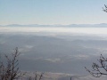
View from Chimney Top
