Channels Trail: Difference between revisions
(→Trail Overview: small edit) |
(→How To Get There: Directions added) |
||
| Line 24: | Line 24: | ||
==How To Get There== | ==How To Get There== | ||
From Kingsport, TN | |||
#Take I-81 north to Virginia Exit 14 (Hwy VA-140/Jonesboro Road) towards Abingdon. | |||
#After 0.5 mile, turn right/east onto US-19/11 Lee Highway | |||
#After 0.9 mile, turn left/north onto US-19/Porterfield Highway. | |||
#After 8.2 miles, turn right slightly and downhill onto Brumley Gap Road (County Road 689). | |||
#Wind 8.2 miles until seeing the Channels State Forest sign on left/north - just past Fletchers Chapel Church on right/south. Church address is 23268 Brumley Gap Road, which Google Maps overshoots. | |||
#Proceed uphill on gravel forest road to kiosk on right which is at turn into main parking for 8-10 cars. | |||
This location is open all year for the entire 5.5 mile trail distance to The Channels. A gate is locked just past this point during the off-season. If the latter is open, then high-clearance vehicles with four-wheel drive could proceed up a couple of miles to an upper parking area to shorten the hike and climb. While the forest road is in great condition, low-clearance sedans would bottom out in the frequent water diversions. | |||
==Route Description== | ==Route Description== | ||
Revision as of 17:32, 2 August 2020
| Channels Trail (log in to submit report) | |
|---|---|

| |
| Highlight | Although your likely goal, not the typical access |
| Park | The Channels Natural Area Preserve |
| Land Owner | Virginia Department of Forestry |
| Located | Rosedale, VirginiaLocation inherited from associated park |
| Trail Marking | Red blaze |
| Trail UseThings allowed to do on or near the trail |
|
| FeaturesThings to see on or near the trail |
|
| Difficulty Rating | Hard |
| Hiking TimeTime from car and back. Includes any time hiking to access this trail. | 8 hrs for entire trail"hrsforentiretrail" is not declared as a valid unit of measurement for this property. round trip |
| Distance: | 5.50 mi8.851 km <br /> trailStrict non-repeating trail length / 11.0 mi17.703 km <br /> round tripTypical or shortest length from the car, hike the trail, and return to car |
| Trail Type | In-and-Out |
| Low / High Point | 1713 ft571 Yards <br />522.122 Meters <br /> / {{{High Point}}}"{{{High Point}}}" is not a number. |
| Elev. Gain/LossSee link for details of calculation. Gain/Loss is direction dependent. | {{{Elevation Gain}}}"{{{Elevation Gain}}}" is not a number. / ({{{Elevation Loss}}}"{{{Elevation Loss}}}" is not a number.) – South-to-North |
| Trip ReportsFrom user "hiked it" submissions<br />Recent is within last 90 days | 2 logged hikes (0 recent) |
| NearbyWithin 5 mi<br />Click link to view list | 2 trails / 8.4 mi of trail |
| Parking | 36° 49' 39.40" N, 81° 57' 44.93" W Map |
| Trailhead | 36° 49' 39.40" N, 81° 57' 44.93" W Map |
|
| |
| Show In Google Maps | |
Download KML / Upload new version / KML File Page / Create Profile Chart / gpsvisualizer Map
Trail Overview
Not the favored hiking route to the The Channels in spite of its name. Shorter when seasonal gates are open, but still lots of climbing.
How To Get There
From Kingsport, TN
- Take I-81 north to Virginia Exit 14 (Hwy VA-140/Jonesboro Road) towards Abingdon.
- After 0.5 mile, turn right/east onto US-19/11 Lee Highway
- After 0.9 mile, turn left/north onto US-19/Porterfield Highway.
- After 8.2 miles, turn right slightly and downhill onto Brumley Gap Road (County Road 689).
- Wind 8.2 miles until seeing the Channels State Forest sign on left/north - just past Fletchers Chapel Church on right/south. Church address is 23268 Brumley Gap Road, which Google Maps overshoots.
- Proceed uphill on gravel forest road to kiosk on right which is at turn into main parking for 8-10 cars.
This location is open all year for the entire 5.5 mile trail distance to The Channels. A gate is locked just past this point during the off-season. If the latter is open, then high-clearance vehicles with four-wheel drive could proceed up a couple of miles to an upper parking area to shorten the hike and climb. While the forest road is in great condition, low-clearance sedans would bottom out in the frequent water diversions.
Route Description
Typical Conditions
Fees, Permits, etc.
After the Hike
Miscellaneous Information
Gallery
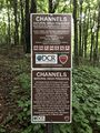
Channels NAP boundary sign
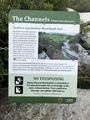
Channels NAP information sign
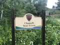
Entrance sign on Brumley Gap Road
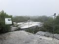
Channels top side enveloped in clouds

Trail Profile
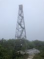
Hayters Knob Firetower - Do not climb!
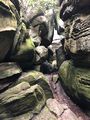
In The Channels
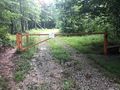
Locked Gate - Start of Shorter Hike
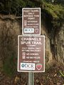
Signs at entrance for Channels spur trail


