Carvers Gap (5512') is the primary road access for the Roan Highlands. TN143 comes from Roan Mountain, TN and NC261 comes from Bakersville, NC. Large parking area with restrooms. The road to the top of Roan Mountain is open from approximately May-October.
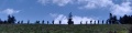
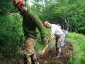
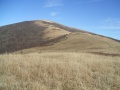
Round Bald (5826') is one of the many famous balds of the Roan Highlands. Round Bald has 360 degree views from its summit. Round Bald is also home to one of the TEHCC's greatest trail maintenance projects - hardened gravel and geotextile over 1 mile of the Trail. This project was completed in 2001.
Jane Bald (5807') is another Roan Highlands bald. It's name is derived from Jane Cook whose sister Harriet died of milk sickness on the bald in November of 1870.
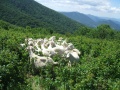
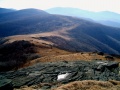
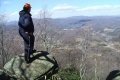
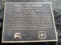
"The Humps" are quite possibly the greatest balds in the southern Appalachians. At 5587', Hump Mountain stands high above the surrounding hills. It's open meadows can be seen from miles away. One shoulder of Hump Mountain is Houston Ridge where a plaque can be found honoring Stan Murray.
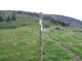
Primitive camp site on the descent of Hump Mountain before reaching US19E. This is the last point where the Trail touches North Carolina.
After descending from the Roan Highlands, the Trail reaches US19E (2880'). A few miles west is the town of Roan Mountain, TN where lodging, food and shuttling can be found. To the east is Elk Park, NC where lodging and food can be found. Parking is NOT recommended here.
Loading map...
{"type":"TERRAIN","minzoom":false,"maxzoom":false,"types":["ROADMAP","SATELLITE","HYBRID","TERRAIN"],"mappingservice":"googlemaps3","width":"auto","height":"600px","centre":false,"title":"","label":"","icon":"","lines":[],"polygons":[],"circles":[],"rectangles":[],"copycoords":false,"static":false,"visitedicon":"","wmsoverlay":false,"zoom":false,"layers":[],"controls":["pan","zoom","type","scale","streetview","rotate"],"zoomstyle":"DEFAULT","typestyle":"DEFAULT","autoinfowindows":false,"resizable":false,"kmlrezoom":false,"poi":true,"cluster":false,"clustergridsize":60,"clustermaxzoom":20,"clusterzoomonclick":true,"clusteraveragecenter":true,"clusterminsize":2,"imageoverlays":[],"kml":[],"gkml":["http://tehcc.org/clubwiki/kml/Appalachian_Trail_05_Carvers_Gap_to_US19E.kml"],"searchmarkers":"","fullscreen":false,"scrollwheelzoom":false,"locations":[{"text":"\u003Cdiv class=\"mw-parser-output\"\u003E\u003Cp\u003EApple House Campsite\n\u003C/p\u003E\u003C/div\u003E","title":"Apple House Campsite\n","link":"","lat":36.17213000000000278078005067072808742523193359375,"lon":-82.0111200000000053478288464248180389404296875,"icon":"/clubwiki/images/MarkerH.png"},{"text":"\u003Cdiv class=\"mw-parser-output\"\u003E\u003Cp\u003EBig Yellow Mountain (5,460 ft)\n\u003C/p\u003E\u003C/div\u003E","title":"Big Yellow Mountain (5,460 ft)\n","link":"","lat":36.11267112249999655659848940558731555938720703125,"lon":-82.028040537999999060048139654099941253662109375,"icon":"/clubwiki/images/MarkerP.png"},{"text":"\u003Cdiv class=\"mw-parser-output\"\u003E\u003Cp\u003ECampsite\n\u003C/p\u003E\u003C/div\u003E","title":"Campsite\n","link":"","lat":36.12731899999999995998223312199115753173828125,"lon":-82.02429200000000264481059275567531585693359375,"icon":"/clubwiki/images/MarkerH.png"},{"text":"\u003Cdiv class=\"mw-parser-output\"\u003E\u003Cp\u003EDoll Flats\n\u003C/p\u003E\u003C/div\u003E","title":"Doll Flats\n","link":"","lat":36.151870999999999867213773541152477264404296875,"lon":-82.0109939999999966175892041064798831939697265625,"icon":"/clubwiki/images/MarkerH.png"},{"text":"\u003Cdiv class=\"mw-parser-output\"\u003E\u003Cp\u003EDoll Flats\n\u003C/p\u003E\u003C/div\u003E","title":"Doll Flats\n","link":"","lat":36.15044803239999993138553691096603870391845703125,"lon":-82.0106024669999982279477990232408046722412109375,"icon":"/clubwiki/images/MarkerG.png"},{"text":"\u003Cdiv class=\"mw-parser-output\"\u003E\u003Cp\u003EElk Hollow Ridge (5,180 ft)\n\u003C/p\u003E\u003C/div\u003E","title":"Elk Hollow Ridge (5,180 ft)\n","link":"","lat":36.11229999999999762394509161822497844696044921875,"lon":-82.0614000000000061163518694229423999786376953125,"icon":"/clubwiki/images/MarkerP.png"},{"text":"\u003Cdiv class=\"mw-parser-output\"\u003E\u003Cp\u003EGrassy Ridge (6,140 ft)\n\u003C/p\u003E\u003C/div\u003E","title":"Grassy Ridge (6,140 ft)\n","link":"","lat":36.09599999999999653255144949071109294891357421875,"lon":-82.0759000000000042973624658770859241485595703125,"icon":"/clubwiki/images/MarkerP.png"},{"text":"\u003Cdiv class=\"mw-parser-output\"\u003E\u003Cp\u003EGrassy Ridge Bald (6,180 ft)\n\u003C/p\u003E\u003C/div\u003E","title":"Grassy Ridge Bald (6,180 ft)\n","link":"","lat":36.0998000000000018872015061788260936737060546875,"lon":-82.08039999999999736246536485850811004638671875,"icon":"/clubwiki/images/MarkerP.png"},{"text":"\u003Cdiv class=\"mw-parser-output\"\u003E\u003Cp\u003EHump Mountain (5,587 ft)\n\u003C/p\u003E\u003C/div\u003E","title":"Hump Mountain (5,587 ft)\n","link":"","lat":36.14020000000000010231815394945442676544189453125,"lon":-82.011899999999997135091689415276050567626953125,"icon":"/clubwiki/images/MarkerP.png"},{"text":"\u003Cdiv class=\"mw-parser-output\"\u003E\u003Cp\u003EJane Bald (5,820 ft)\n\u003C/p\u003E\u003C/div\u003E","title":"Jane Bald (5,820 ft)\n","link":"","lat":36.10600000000000164845914696343243122100830078125,"lon":-82.093400000000002592059900052845478057861328125,"icon":"/clubwiki/images/MarkerP.png"},{"text":"\u003Cdiv class=\"mw-parser-output\"\u003E\u003Cp\u003ELittle Hump Mountain (5,460 ft)\n\u003C/p\u003E\u003C/div\u003E","title":"Little Hump Mountain (5,460 ft)\n","link":"","lat":36.12480000000000046611603465862572193145751953125,"lon":-82.0288000000000039335645851679146289825439453125,"icon":"/clubwiki/images/MarkerP.png"},{"text":"\u003Cdiv class=\"mw-parser-output\"\u003E\u003Cp\u003EOvermountain Barn\n\u003C/p\u003E\u003C/div\u003E","title":"Overmountain Barn\n","link":"","lat":36.123615000000000918589648790657520294189453125,"lon":-82.054214000000001760781742632389068603515625,"icon":"/clubwiki/images/MarkerF.png"},{"text":"\u003Cdiv class=\"mw-parser-output\"\u003E\u003Cp\u003EParking\n\u003C/p\u003E\u003C/div\u003E","title":"Parking\n","link":"","lat":36.1170074500000026773705030791461467742919921875,"lon":-82.0489487130000014758479665033519268035888671875,"icon":"/clubwiki/images/MarkerA.png"},{"text":"\u003Cdiv class=\"mw-parser-output\"\u003E\u003Cp\u003EParking\n\u003C/p\u003E\u003C/div\u003E","title":"Parking\n","link":"","lat":36.106377682800001593932393006980419158935546875,"lon":-82.1111527949999953079895931296050548553466796875,"icon":"/clubwiki/images/MarkerA.png"},{"text":"\u003Cdiv class=\"mw-parser-output\"\u003E\u003Cp\u003EParking\n\u003C/p\u003E\u003C/div\u003E","title":"Parking\n","link":"","lat":36.1774255668999984436595696024596691131591796875,"lon":-82.011786817000000837651896290481090545654296875,"icon":"/clubwiki/images/MarkerA.png"},{"text":"\u003Cdiv class=\"mw-parser-output\"\u003E\u003Cp\u003ERestrooms\n\u003C/p\u003E\u003C/div\u003E","title":"Restrooms\n","link":"","lat":36.1064640000000025565896066837012767791748046875,"lon":-82.1113280000000003155946615152060985565185546875,"icon":"/clubwiki/images/MarkerQ.png"},{"text":"\u003Cdiv class=\"mw-parser-output\"\u003E\u003Cp\u003ERoan High Bluff (6,267 ft)\n\u003C/p\u003E\u003C/div\u003E","title":"Roan High Bluff (6,267 ft)\n","link":"","lat":36.09320000000000305817593471147119998931884765625,"lon":-82.145499999999998408384271897375583648681640625,"icon":"/clubwiki/images/MarkerP.png"},{"text":"\u003Cdiv class=\"mw-parser-output\"\u003E\u003Cp\u003ERoan High Knob (6,285 ft)\n\u003C/p\u003E\u003C/div\u003E","title":"Roan High Knob (6,285 ft)\n","link":"","lat":36.10459999999999780584403197281062602996826171875,"lon":-82.122399999999998954081092961132526397705078125,"icon":"/clubwiki/images/MarkerP.png"},{"text":"\u003Cdiv class=\"mw-parser-output\"\u003E\u003Cp\u003ERound Bald (5,820 ft)\n\u003C/p\u003E\u003C/div\u003E","title":"Round Bald (5,820 ft)\n","link":"","lat":36.106999999999999317878973670303821563720703125,"lon":-82.1039999999999992041921359486877918243408203125,"icon":"/clubwiki/images/MarkerP.png"},{"text":"\u003Cdiv class=\"mw-parser-output\"\u003E\u003Cp\u003EStan Murray\n\u003C/p\u003E\u003C/div\u003E","title":"Stan Murray\n","link":"","lat":36.11236199999999740839484729804098606109619140625,"lon":-82.0657340000000061763785197399556636810302734375,"icon":"/clubwiki/images/MarkerF.png"},{"text":"\u003Cdiv class=\"mw-parser-output\"\u003E\u003Cp\u003EStanley Murray Memorial\n\u003C/p\u003E\u003C/div\u003E","title":"Stanley Murray Memorial\n","link":"","lat":36.13965593799999709290204918943345546722412109375,"lon":-82.0112594410000070865862653590738773345947265625,"icon":"/clubwiki/images/MarkerG.png"},{"text":"\u003Cdiv class=\"mw-parser-output\"\u003E\u003Cp\u003EStile over fence\n\u003C/p\u003E\u003C/div\u003E","title":"Stile over fence\n","link":"","lat":36.13930178609999899208560236729681491851806640625,"lon":-82.00031777899999951841891743242740631103515625,"icon":"/clubwiki/images/MarkerG.png"},{"text":"\u003Cdiv class=\"mw-parser-output\"\u003E\u003Cp\u003EStile over fence\n\u003C/p\u003E\u003C/div\u003E","title":"Stile over fence\n","link":"","lat":36.13839015549999800214209244586527347564697265625,"lon":-82.0154126030000014679899322800338268280029296875,"icon":"/clubwiki/images/MarkerG.png"}]}