Blackstack Cliffs (AT): Difference between revisions
| (28 intermediate revisions by 6 users not shown) | |||
| Line 2: | Line 2: | ||
{{Infobox Trail | {{Infobox Trail | ||
| Image Name = Blackstack_Cliffs1jpg.jpg | | Image Name = Blackstack_Cliffs1jpg.jpg | ||
| City = Greeneville | |||
| City = | |||
| State = Tennessee | | State = Tennessee | ||
| Marking = None | |||
| Trail Use = {{Hike}} | | Trail Use = {{Hike}} | ||
| Difficulty Rating = Moderate | | Difficulty Rating = Moderate | ||
| Hike Time = 1.5 | | Hike Time = 1.5 | ||
| Distance = 1.1 | | Distance = 1.1 | ||
| Elevation Gain = | | Elevation Gain = ~0 | ||
| High Point = | | High Point = 4,452 | ||
| Latitude = 36.03462 | | Latitude = 36.03462 | ||
| Longitude = -82.70177 | | Longitude = -82.70177 | ||
| Medical = | | Medical = Greeneville | ||
}} | }} | ||
<!-- End Infobox template table--> | <!-- End Infobox template table--> | ||
{{Trail page needs | |||
| Hide needs = | |||
| KML = Yes | |||
| Updated KML = | |||
| Detail route description = Yes | |||
| Photos = Yes | |||
| Winter photos = | |||
| Remove prefix = | |||
| Update infobox = Yes | |||
| Infobox data update = Yes | |||
| Trail pins = Yes | |||
| Other = | |||
| Comment = Possibly another picture or two if any are of note | |||
| Date reviewed = 10/19/2015 | |||
}} | |||
<!-- Start of Main Page --> | <!-- Start of Main Page --> | ||
== Trail Overview == | == Trail Overview == | ||
<!-- Enter a overview of the trail. What attracts you to this trail, points of interest, types of flowers, lakes, and peaks that you see along the way. --> | <!-- Enter a overview of the trail. What attracts you to this trail, points of interest, types of flowers, lakes, and peaks that you see along the way. --> | ||
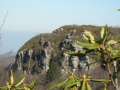
A short spur off | A short spur off Appalachian Trail through rhododendron leads to overlook from these cliffs - great lunch spot. | ||
== How to get there == | == How to get there == | ||
<!-- Please enter detailed instruction on how to find the trail head. --> | <!-- Please enter detailed instruction on how to find the trail head. --> | ||
From Greeneville, TN | |||
#Take | #Take TN-107/TN-70 south out of town for 15 miles. | ||
#Turn | #Turn left onto Viking Mountain Road for 6.5 miles. | ||
# | #Which becomes gravel Bald Mountain Road for last couple of miles. | ||
#Park | #Park in Jones Meadow at turnaround | ||
== Route Description== | == Route Description== | ||
<!-- Detailed description of the route. Is there any side trails that are worth traveling? --> | <!-- Detailed description of the route. Is there any side trails that are worth traveling? --> | ||
Toward the very end of the paved road going through Jones Meadow, you will see an unpaved road forking off to your right marked with blue blazes. This is a spur trail (not suitable for vehicles) that leads to the Appalachian Trail. Park near this blue-blazed spur trail. Following the blue-blazed trail for about 0.2 miles, you will come upon a small clearing with multiple trails going in different directions. Continue straight through the clearing, following the blue blazed trail until you come to the white-blazed AT. Head north-bound (left) on the white-blazed AT for 0.2 miles. In a turn, there is a brown sign stated Blackstack Cliff for an unmarked spur trail up the hill. Continue for ~75 yards to a stone ledge with a US Forest Service benchmark. Take the big steps down and proceed until you emerge at the cliffs. | |||
== Typical Conditions == | == Typical Conditions == | ||
<!-- Typical conditions throughout the year of what to expect on the trail. Rocky, muddy, sandy, flowers, lots of downed trees? --> | <!-- Typical conditions throughout the year of what to expect on the trail. Rocky, muddy, sandy, flowers, lots of downed trees? --> | ||
The spur trail is rather rocky and inclined at times, but the rhododendron that once made the spur trail somewhat difficult to navigate have been cleared. | |||
==Fees, Permits, etc. == | ==Fees, Permits, etc. == | ||
<!-- Please list any Fees, Permits, Regulations, etc. that may be required on this trail.--> | <!-- Please list any Fees, Permits, Regulations, etc. that may be required on this trail.--> | ||
No fee or permit to visit | |||
== After the Hike == | == After the Hike == | ||
<!-- Other things to check out while you're in the area. Restaurants, attractions, monuments, etc... --> | <!-- Other things to check out while you're in the area. Restaurants, attractions, monuments, etc... --> | ||
If the nearby firetower on Camp Creek Bald is open, then tremendous views can be observed. Recommended second leg for a hike up here on Viking Mountain. | |||
After hikes in 2009, pizza and pasta were enjoyed at the Brick Oven Italian Restaurant in Greeneville, TN (follow TN107 back to 1001 W Main Street). | |||
== Misc. Information == | == Misc. Information == | ||
<!-- Enter any additional information that doesn't fit an any other fields. Does this trail require any permits for overnight? parking? --> | <!-- Enter any additional information that doesn't fit an any other fields. Does this trail require any permits for overnight? parking? --> | ||
== Maps == | == Maps == | ||
<!-- You can place pictures, PDF's, links, or even create a Google map with your waypoints and place it here. --> | <!-- You can place pictures, PDF's, links, or even create a Google map with your waypoints and place it here. --> | ||
<!-- 36.0298,-82.7096 Camp Creek Bald (parking) --> | |||
== Photos == | == Photos == | ||
<gallery> | <gallery> | ||
<!-- Place any pictures from this trail below. Add a picture by typing Image:imagename.extension --> | <!-- Place any pictures from this trail below. Add a picture by typing Image:imagename.extension --> | ||
Image: | Image:Blackstack_Cliffs2.jpg|View of Blackstack Cliffs from parking area | ||
<!-- Do not remove the end gallery code.--> | <!-- Do not remove the end gallery code.--> | ||
</gallery> | </gallery> | ||
<!-- | <!-- Categories - Keep in mind the titles are case sensitive. --> | ||
[[Category:Tennessee]][[Category:Overlook]] | [[Category:Tennessee]] [[Category:Overlook]] [[Category:Medium]] [[Category:Appalachian Trail]] | ||
Latest revision as of 11:14, 30 July 2018
| |||||||||||||||||||||||||||||||||||||

Trail Overview[edit]
A short spur off Appalachian Trail through rhododendron leads to overlook from these cliffs - great lunch spot.
How to get there[edit]
From Greeneville, TN
- Take TN-107/TN-70 south out of town for 15 miles.
- Turn left onto Viking Mountain Road for 6.5 miles.
- Which becomes gravel Bald Mountain Road for last couple of miles.
- Park in Jones Meadow at turnaround
Route Description[edit]
Toward the very end of the paved road going through Jones Meadow, you will see an unpaved road forking off to your right marked with blue blazes. This is a spur trail (not suitable for vehicles) that leads to the Appalachian Trail. Park near this blue-blazed spur trail. Following the blue-blazed trail for about 0.2 miles, you will come upon a small clearing with multiple trails going in different directions. Continue straight through the clearing, following the blue blazed trail until you come to the white-blazed AT. Head north-bound (left) on the white-blazed AT for 0.2 miles. In a turn, there is a brown sign stated Blackstack Cliff for an unmarked spur trail up the hill. Continue for ~75 yards to a stone ledge with a US Forest Service benchmark. Take the big steps down and proceed until you emerge at the cliffs.
Typical Conditions[edit]
The spur trail is rather rocky and inclined at times, but the rhododendron that once made the spur trail somewhat difficult to navigate have been cleared.
Fees, Permits, etc.[edit]
No fee or permit to visit
After the Hike[edit]
If the nearby firetower on Camp Creek Bald is open, then tremendous views can be observed. Recommended second leg for a hike up here on Viking Mountain.
After hikes in 2009, pizza and pasta were enjoyed at the Brick Oven Italian Restaurant in Greeneville, TN (follow TN107 back to 1001 W Main Street).
Misc. Information[edit]
Maps[edit]
Photos[edit]
View of Blackstack Cliffs from parking area
