Blackstack Cliffs (AT): Difference between revisions
(COCIHcbvvIoC) |
(reverting vandalism) |
||
| Line 1: | Line 1: | ||
<!-- The following few lines create the "Infobox" table template. Please scroll down to edit the main content of the article. --> | |||
{{Infobox Trail | |||
| Image Name = Blackstack_Cliffs1jpg.jpg | |||
| Trail No. = * | |||
| City = Greenville | |||
| State = Tennessee | |||
| Trail Use = {{Hike}} | |||
| Season = * | |||
| Difficulty Rating = Moderate | |||
| Hike Time = 1.5 | |||
| Distance = 1.1 | |||
| Elevation Gain = ~0 | |||
| High Point = 4,452 | |||
| Latitude = 36.03462 | |||
| Longitude = -82.70177 | |||
| Medical = Greeneville | |||
<!-- DON'T EDIT THE GOOGLEMAP TAG --> | |||
| googlemap = | |||
<googlemap lat="36.03462" lon="-82.70177" zoom="12" width="270" type="terrain" height="180" selector="no" controls="small"> | |||
36.88395,-82.7881,Blackstack Cliffs | |||
36.0298,-82.7096,Camp Creek Bald (parking) | |||
</googlemap> | |||
}} | |||
<!-- End Infobox template table--> | |||
<!-- Start of Main Page --> | |||
== Trail Overview == | |||
<!-- Enter a overview of the trail. What attracts you to this trail, points of interest, types of flowers, lakes, and peaks that you see along the way. --> | |||
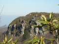
A short spur off Applachian Trail through rhododendron leads to overlook from these cliffs - great lunch spot. | |||
== How to get there == | |||
<!-- Please enter detailed instruction on how to find the trail head. --> | |||
From Greeneville, TN | |||
#Take TN-107/TN-70 south out of town for 15 miles. | |||
#Turn left onto Viking Mountain Road for 6.5 miles. | |||
#Which becomes gravel Bald Mountain Road for last couple of miles. | |||
#Park at turnaround | |||
== Route Description== | |||
<!-- Detailed description of the route. Is there any side trails that are worth traveling? --> | |||
Upon Camp Creek Bald, find the blue blazes down the middle of a paved road which is the spur trail over to the AT. Head north-bound on the white-blazed AT for 0.4 miles. In a turn, there is a brown sign stated Blackstack Cliff for an unmarked spur trail up the hill. Continue through the rhododendron to a stone ledge with a US Forest benchmark. Take the big steps down and proceed through more rhododendron until you emerge at the cliffs. | |||
== Typical Conditions == | |||
<!-- Typical conditions throughout the year of what to expect on the trail. Rocky, muddy, sandy, flowers, lots of downed trees? --> | |||
==Fees, Permits, etc. == | |||
<!-- Please list any Fees, Permits, Regulations, etc. that may be required on this trail.--> | |||
No fee or permit to visit | |||
== After the Hike == | |||
<!-- Other things to check out while you're in the area. Restaurants, attractions, monuments, etc... --> | |||
After hikes in 2009, enjoyed pizza and pasta at the Brick Oven Italian Restaurant in Greeneville, TN (follow TN107 back to 1001 W Main St.) | |||
== Misc. Information == | |||
<!-- Enter any additional information that doesn't fit an any other fields. Does this trail require any permits for overnight? parking? --> | |||
== Maps == | |||
<!-- You can place pictures, PDF's, links, or even create a Google map with your waypoints and place it here. --> | |||
== Photos == | |||
<gallery> | |||
<!-- Place any pictures from this trail below. Add a picture by typing Image:imagename.extension --> | |||
Image:Blackstack_Cliffs2.jpg|View of Blackstack Cliffs from parking area | |||
<!-- Do not remove the end gallery code.--> | |||
</gallery> | |||
<!-- Finally add the trail to any Categories it should belong to. Please keep the State category. To make a new category just type [[Category:mycategory]]. Keep in mind categories are case sensitive. --> | |||
[[Category:Tennessee]][[Category:Overlook]][[Category:Medium]] | |||
Revision as of 10:55, 20 May 2011
| |||||||||||||||||||||||||||||||||||||

Trail Overview
A short spur off Applachian Trail through rhododendron leads to overlook from these cliffs - great lunch spot.
How to get there
From Greeneville, TN
- Take TN-107/TN-70 south out of town for 15 miles.
- Turn left onto Viking Mountain Road for 6.5 miles.
- Which becomes gravel Bald Mountain Road for last couple of miles.
- Park at turnaround
Route Description
Upon Camp Creek Bald, find the blue blazes down the middle of a paved road which is the spur trail over to the AT. Head north-bound on the white-blazed AT for 0.4 miles. In a turn, there is a brown sign stated Blackstack Cliff for an unmarked spur trail up the hill. Continue through the rhododendron to a stone ledge with a US Forest benchmark. Take the big steps down and proceed through more rhododendron until you emerge at the cliffs.
Typical Conditions
Fees, Permits, etc.
No fee or permit to visit
After the Hike
After hikes in 2009, enjoyed pizza and pasta at the Brick Oven Italian Restaurant in Greeneville, TN (follow TN107 back to 1001 W Main St.)
Misc. Information
Maps
Photos
View of Blackstack Cliffs from parking area
