AT - Little Rock Knob: Difference between revisions
(→Trail Overview: initial wording) |
(→How to get there: Update directions for Hughes Gap) |
||
| Line 31: | Line 31: | ||
#Continue through Elizabethton and right at traffic light to stay on US-321 South. | #Continue through Elizabethton and right at traffic light to stay on US-321 South. | ||
#At Hampton, stay on US19E as it veers right. | #At Hampton, stay on US19E as it veers right. | ||
#At Roan Mountain, | #At Roan Mountain, turn right onto TN-143. Pass through Roan Mountain State Park. | ||
# | #After just over five miles, turn right onto Cove Creek Road. | ||
#Veer right after a mile to stay on Hughes Gap Road. | |||
#At the state line, there is a small (four car) pull-off on right. | |||
(Alternatively at Steps 2-3, once just inside Elizabethton city limits, turn right on TN-362, then right again and follow Gap Creek Rd for 8 miles to US19E, thus bypassing around Elizabethton and Hampton.) | (Alternatively at Steps 2-3, once just inside Elizabethton city limits, turn right on TN-362, then right again and follow Gap Creek Rd for 8 miles to US19E, thus bypassing around Elizabethton and Hampton.) | ||
== Route Description== | == Route Description== | ||
Revision as of 20:49, 26 August 2012
| |||||||||||||||||||||||||||||||||||||
Trail Overview
--- Page being written 8/26/2012
Hike along the Appalachian Trail through hardwood forest to great views at Little Rock Knob (elevation 4918').
How to get there
From Kingsport, TN
- Take I-26 south to Exit 24 for US-321/TN-67 toward Elizabethton.
- Continue through Elizabethton and right at traffic light to stay on US-321 South.
- At Hampton, stay on US19E as it veers right.
- At Roan Mountain, turn right onto TN-143. Pass through Roan Mountain State Park.
- After just over five miles, turn right onto Cove Creek Road.
- Veer right after a mile to stay on Hughes Gap Road.
- At the state line, there is a small (four car) pull-off on right.
(Alternatively at Steps 2-3, once just inside Elizabethton city limits, turn right on TN-362, then right again and follow Gap Creek Rd for 8 miles to US19E, thus bypassing around Elizabethton and Hampton.)
Route Description
Follow the white AT blazes southbound up and up, and then return. Pace was just over mile/hour going up and almost three mph coming back down.
| Distance (mi) | Elevation (ft) | Feature |
|---|---|---|
| 0.0 | 2,880 | Trailhead at US19E |
| 0.5 | Campground at former Apple House Shelter | |
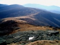
| 2.6 | 4,400 | Trail reaches a rock overlook with view down into Elk River valley |
| 3.0 | 4,560 | Reach grassy field called Doll Flats |
| 4.6 | Exit woods at fence sty to begin ascending Houston Ridge up the bald | |
| 5.5 | 5,587 | Summit Hump Mountain. Spin around to take in the views. |
Typical Conditions
Maintained Appalachian Trail. Varies from excellent dirt tread to a very rock path to a deep groove up the bald. Can have water flowing down trail if the water bars are not functioning. Trekking poles were well used on the return trip to stabilize the descent.
Fees, Permits, etc.
No permits or fees required. If camping, stay is the prearranged sites to minimize impact.
After the Hike
Misc. Information
Maps
<googlemap version="0.9" lat="36.16" lon="-82.015" type="terrain" zoom="13" scale="yes" icons="http://tehcc.org/clubwiki/kml/marker{label}.png"> http://tehcc.org/clubwiki/kml/AT_US19E_to_Hump_Mtn.kml
(A) 36.177234,-82.01189 Parking at US19E (G) 36.1402,-82.01173 Hump Mountain (G) 36.15227,-82.01147 Doll Flats </googlemap>
Photos
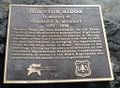
Plaque on Houston Ridge for Stan Murray

