Amy received a B.S. in Biology from Armstrong Atlantic State University in 2006. As a graduation present to herself, she decided to thru-hike the Appalachian Trail. During her hike, she witnessed the dramatic devastation of the forest caused by the gypsy moth invasion. This experience inspired her to pursue a M.S. in Entomology from Virginia Tech. Since graduation in 2011, she has been working towards forest protection in the natural sciences and natural resources fields. In her free time, Amy enjoys hiking, whitewater kayaking, and mountain biking. She can be reached at asnyder@appalachiantrail.org.
I updated a good amount of content during the month of October, including Rogers Ridge Horse Trail, Bays Mountain, and Warriors’ Path State Park . It’s becoming too much work to go out hiking! As for the inner workings, I’ve turned back on anonymous edits and user account creation. It’s working great to stop the vandals, but still no new editors have been contributing. I’ve also started a concept of “hike plans.” These will be pages that assemble a collection of trail hikes into a single plan. Bays Mountain and their network of trails are prime examples of needing hike plans. An 11 miles tour of structures within the park is an early example. I call it the Bays Mountain Structure Tour and will lead this hike as part of the fall Expo.
Speaking of contributing, it is a wiki and, yes, we would love your help. We have documented 168 trails, some with little more than just their trail name, and I know there are many more within a 2-4hr drive that we haven’t even listed yet. Although I promise that wiki editing is easy and that you can’t permanently mess it up (all edits are saved, past versions can be reviewed, and edits can always be undone), you can always email me at tim@tehcc.org with any desired corrections. But get in there, try out wiki editing, and help make this site the resource to find out about great hikes in our area.
Come burn off some turkey and stuffing and hike to see the 8th wonder of Colonial Heights – a stream sinking into a hole. Since REI has been in the news we have also rebranded this as our “Opt Outside” hike. This hike will be Family/Beginner friendly as it will have small children along for the hike. Meet at the pool parking lot at 1:30 PM to caravan over to the Sinking Waters trail head or if you know where it is, meet us there. Reservations not required but appreciated so we know to look for you. Contact Carrie Schaefer (carrie@tehcc.org).
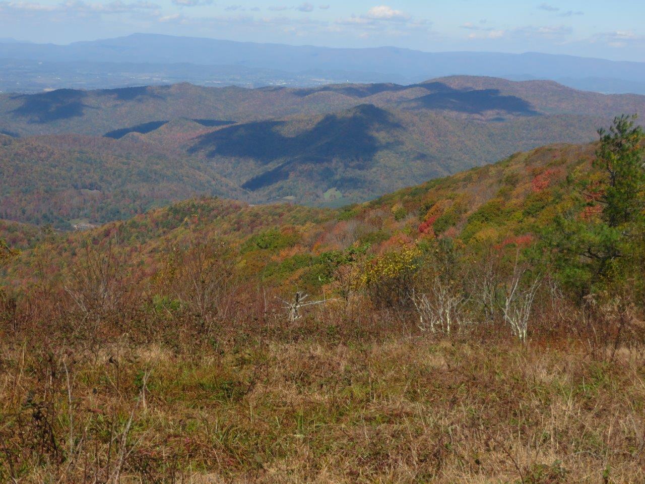
View South-East from the first bald clearing of Rogers Ridge
Rogers Ridge Horse Trail is an in-and-out 6.87 mile long ridge line trail. It’s a long hill climb trail for a day hike but near the end, the 360° views of the surrounding ridge lines all make it worth it. A side benefit of this hike is being able to reach the Tri-State Corner Knob junction of TN-NC-VA. The trail begins in the Horse Ridge Scenic Area of the Cherokee National Forest past Damascus near Laurel Bloomery, TN. Horses are allowed, but on a recent October 2015 trip, there was little evidence of them. Although clearly marked at the trail head that ATV/ORV vehicles were not allowed, signs of their recent presence was along the entire trail. The hike begins with an immediate creek crossing that has neither a bridge or decent rocks to hop across, but this will be the last time you see water. Although guide books mention some camp sites along the way with water access, we didn’t see them. The trail wastes no time in getting to your 3,201 feet of climbing as it’s nearly a consistent slope up to the summit. The trail itself is very well marked with Yellow rectangle blazes, but several unmarked and well worn trails connect along the way. It may be possible that one of them connects to the Gentry Creek Falls trail that would make for a nice loop trail. The trail itself is wide with a clear “two-track” appearance with the occasional water logged rut to walk around. While not noticed on the ascent, the descent can be challenging for the ankles as there are several sections of loose rocks fist sized and smaller.
View from the upper part of Rogers Ridge Bald
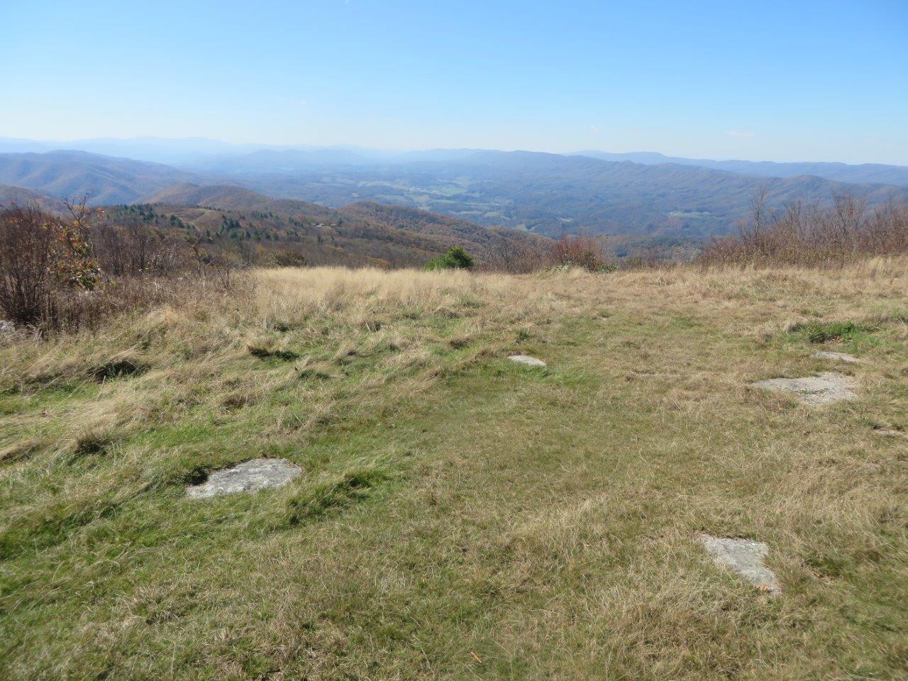
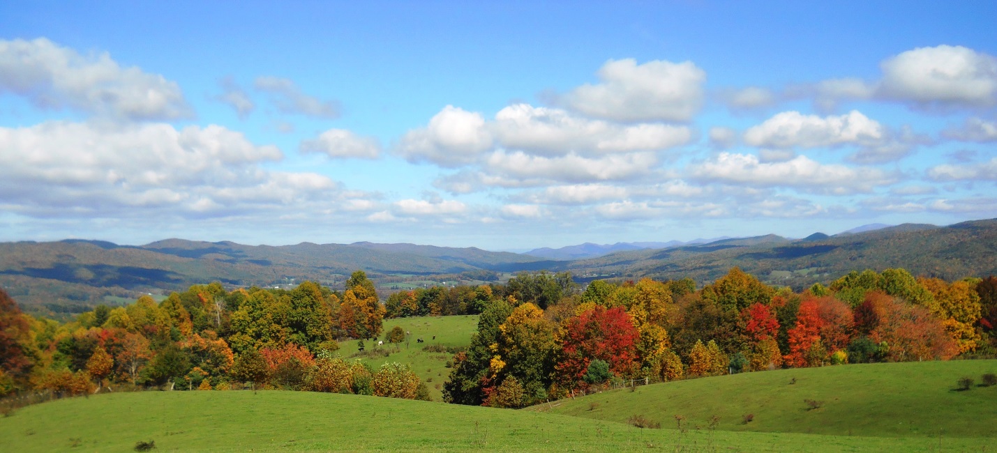
After hiking for 5.33 miles with glimpses through the trees of mountains and neighboring ridge lines, you finally enter a clearing to enjoy the views. The trail may “officially” end here as the previously well blazed path now lacks markings, but you can continue on to enjoy the views. From here you can take a side trip to the south to get an early view of the surrounding ridge lines and valley including Grandfather Mountain. Continuing on the trail to the north, you reach another bald clearing that could suit well for camping, especially large groups. The only reservation I myself have about camping here is the apparent frequent use of ORV’s here. From this higher elevation, there are views of Whitetop Mountain and Mt Rogers Mountain to the northeast. Throughout these tree bald clearings, blackberry bushes appear to be growing rampant. If you can tolerate the thorns, the blackberry picking in the summer must be unlimited! In a bald clearing to the east towards the state line is the trail high point in the final bald clearing. Although various sources differ on the exact measurement, we measured by GPS at 4,900 feet. The ridge top home seen to the south appears to have been severely vandalized. Although unfortunate for the owner, one can only hope that one day this majestic ridge line and profile can be returned to its original natural glory. After the high point, the trail begins to consistently descend for the first time, and ends at a trail/road. Turn left to continue the descent to find the Tri-State Corner Knob, the (at least at one time) terminus of this trail.
View of Whitetop Mountain and Mt Rogers from Rogers Ridge
When visited in October of 2015 the hike was an enjoyable day of near complete solitude. The only encounter was a couple in a truck near the trail terminus. Unexpectedly we found the tree colors to be apparently in their early stages to the south and west, and finding only bare trees to the north and east. Regardless, the day of fresh air, views, and exercise was more than enough to make this a great trail to visit that you should consider as well.
Submitted by Vic Hasler based on website post by Terry Dougherty, Rental Equipment Coordinator (rental@tehcc.org)
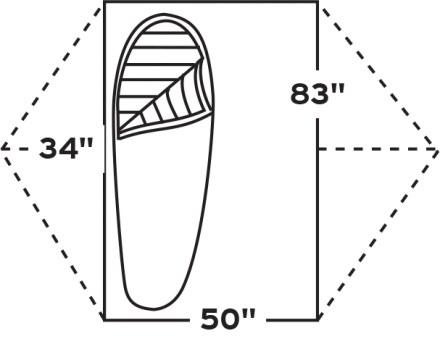
The well-worn two-person REI Half Dome tent (probably from 1999) was replaced in May 2014 with a greatly updated Kelty TraiLogic TN2. Its novel feature is the “stargazing” fly which rolls back for unobstructed nighttime views, but deploys cover easily without exiting the shelter in case the weather changes. The new tent is about a pound lighter at 4 lb, 13 oz, and six inches narrower, but has two vestibules to stash gear under the fly. It packs into a tight 14” x 11” x 3” box shape. It was purchased for just under $240 from Mahoney’s.
We’re on the home stretch to our Fall Expo. All are welcome, members or prospective customers. The only charged event is the chili cook off with food, drinks, and desserts.
8:30a – two hikes to pick from, a Bays Mountain cross-park hike, and a Bays tour of the structures within
1pm – a paddling trip on the North Fork Holston River
3pm – Vendor displays and topic tables for discussion
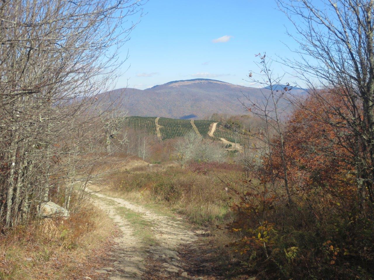
The cold and rainy day prior turned into a beautiful autumn Sunday afternoon; however, I ended up hiking alone, although a dozen backpackers were seen proceeding north on the Trail and one south. The fall color was a few days before peak with some individual trees providing dazzling displays. The hike started as planned with the 0.8-mile crossing of the open farm pasture with views north up the valley. The cattle were ready to be let in from the middle field to be fed at the barn. The walk continued roughly another half hour into the woods, and then returned to the parking lot. I decided to check out the new trail relocation south of the Cross Mountain parking lot, so proceeded a mile south just past the bog bridges. The falling leaves allowed the tread to be less muddy. With the remaining afternoon, I visited two places at Shady Valley managed by The Nature Conservancy at Schoolyard Springs and Orchard Bog. The winding drive on US 421 was enjoyed in the fading daylight.
A day prior, we decided to do a last minute change up. Based on prior reports of the fire tower being popular for fall hikers we decided to look for a road less traveled. We settled on Rogers Ridge Horse Trail. See the wiki page or this month’s Feature of the Month for technical trail details, but it turned out to be a fantastic day of hiking. With our few side trips, the GPS logged us for a 15.5 mile day of hiking. It was also a very solitary hike. On a weekend when many should have been heading out to bald vistas like this, we saw absolutely no one except for a couple in a truck near the Tri-State Corner Knob of TN-VA-NC. Although we had decent glimpses of the surrounding ridges, we were truly rewarded at 5.33 miles when we entered the first bald clearing. We took a side trip to the left for some early views before resuming the ridge hike to the right. A vandalized cabin on the bald ridge peak of Stone Mountain, provided many topics of conversation. We completed the outbound hike with a view of the prior mentioned Tri-State Corner Knob. Some maps suggested that we could have returned by way of the doing Gentry Creek Falls in the reverse, but how was not clear. After hiking 8+mi at that point, we didn’t want to inadvertently add a few more by taking a wrong turn to only have to turn back. Overall the trail was fairly well marked for the specified trail, but none of the many well used connections were marked. Also, despite many signs at the trail head saying differently, the trail is obviously used routinely by Off-Road Vehicle riders. Joining me on this hike was Charlie Outlaw.
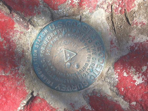
View of Whitetop Mountain and Mt. Rogers near Tri-State Corner KnobView from the baldsView of the survey marker at the junction of TN-VA-NC


 day prior, we decided to do a last minute change up. Based on prior reports of the fire tower being popular for fall hikers we decided to look for a road less traveled. We settled on